2013 National Tsunami Hazard Model
Database
This is the 2013 version of the National Tsunami Hazard Model, and the first to cover all coasts of New Zealand. It provides estimates of the maximum tsunami height at the coast to be expected within specified time periods and confidence levels.
Overview
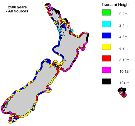
This dataset defines the maximum expected tsunami height (maximum amplitude) for return periods of 100, 500 and 2500 years at the 50th and 84th percentile of confidence, as estimated by the model described in Power (2013). The dataset also defines the coastal sections that were used for this modelling. The maximum expected tsunami heights are presented for each of these coastal sections.
Please note that the maximum expected tsunami height will typically only occur at one location within each coastal section. It is a conservative (pessimistic) assumption if this height is used throughout the section.
This model has been used as a basis for defining tsunami evacuation zones for several regions of the country, and for estimates of the tsunami risk posed to people and buildings.
-
Terms of Use
This data has been prepared by the Institute of Geological and Nuclear Sciences Limited (GNS Science) exclusively for and under contract to the Ministry of Civil Defence and Emergency Management. Unless otherwise agreed in writing by GNS Science, GNS Science accepts no responsibility for any use of, or reliance on any contents of this data by any person other than the Ministry of Civil Defence and Emergency Management and shall not be liable to any person other than the Ministry of Civil Defence and Emergency Management, on any ground, for any loss, damage or expense arising from such use or reliance.
This data is intended to be used in conjunction with Power (2013), and with acknowledgement of the limitations of the methodology expressed there (and in particular those on page 169 of that report).
-
Downloads
Download the dataset (ZIP, 766 KB)
Review of Tsunami Hazard in New Zealand, 2013 Update (PDF, 11 MB)
Key results from this report are available in the form of GIS Shapefiles.2013 All-Coast Tsunami Hazard Data (PDF, 29 MB)
More detailed results for individual 20km sections of coast, including hazard curves and deaggregation plots, can be found in this report
Cite as: GNS Science. (2013). National Tsunami Hazard Model - 2013. GNS Science. https://doi.org/10.21420/2Y8C-2D58
Find more content related to:
GNS Science topics
Locations
- Te Tai-o-Aorere / Tasman
- Rangitāhua / Kermadec Islands
- Rēkohu / Chatham Islands
- Rakiura / Stewart Island
- Murihiku / Southland
- Ōtepoti / Dunedin
- Ōtākou / Otago
- Ōtautahi / Christchurch
- Waitaha / Canterbury
- Kaikōura
- Te Tai Poutini / West Coast
- Te Tauihu-o-te-waka/ Marlborough
- Whakatū / Nelson
- Antarctica
- Te Whanga-nui-a-Tara / Wellington
- Manawatū-Whanganui
- Central Plateau
- Taranaki
- Te Matau-a-Māui / Hawke's Bay
- Te Tai Rāwhiti / Gisborne
- Te Moana-a-Toi / Bay of Plenty
- Waikato
- Tāmaki Makaurau / Auckland
- Te Tai Tokerau / Northland
- Aotearoa / New Zealand
- Pacific Islands