Tsunami
GNS Science works with a number of groups, including NIWA, universities, private individuals and international organizations to improve the knowledge of tsunami hazards and risks in Aotearoa New Zealand.
Our expertise
Our tsunami expertise is enhanced by world-class teams of earthquake engineers, seismologists, geodesists and social scientists, who work in an integrated manner to inform and validate all tsunami science. We identify tsunami sources, model tsunami generation, propagation and inundation, and determine the likely impacts on people, buildings and infrastructure. We also provide advice on effective warning systems, public response, education and evacuation to protect lives and assets.
Our research
GNS researchers study past tsunamis, learn from present tsunami and apply their research to predict future tsunami.
New Zealand: Joining the Tsunami Ready global community
-
Studying the past
Geological samples provide evidence of tsunami that have occurred before human record. Marine sediment deposits in geological samples that are found significantly inland tell us that New Zealand has historically experienced tsunami that were many metres high and travelled many metres and even kilometres inland. We also search out data on the sources, damage and wave heights of tsunami in the recent past (the past 200 years). These data are used to calibrate mathematical models of inundation and impact.
-
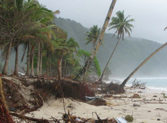
Learning from the present
We use data from the Pacific Tsunami Warning Centre, our DART network and our tsunami gauges to learn about characteristics of tsunami in real time and how they move through the Pacific. We visit sites in the Pacific where tsunami have recently occurred to learn more about the extent of the tsunami and the damage and hazards caused.
-
Predicting the future
Modelling allows us to determine which parts of New Zealand’s coastline are most vulnerable to tsunami. We run hypothetical scenarios of potential future tsunami-causing events (earthquakes, volcanoes and undersea landslides) off the New Zealand coast and model the type of tsunami likely to occur under a given scenario. This helps us determine likely impacts on people, buildings and infrastructure. We also use modelling to determine the likely long-term economic losses to New Zealand cities from tsunami.
-
Helping our Pacific community
The central goal that underpins all of our research is to provide useful information that can be applied to predict and manage tsunami risk and hazards in New Zealand and overseas. Our research has been applied in a number of ways:
- We have built a national tsunami hazard model that predicts the maximum possible tsunami wave height for coastal areas throughout New Zealand.
- We prepare tsunami evacuation maps for Civil Defence and Emergency Management groups in New Zealand. These maps delimit possible tsunami inundation in populated coastal areas and identify key escape routes for people in the event of a tsunami alert.
- We research the awareness of geological hazards held by the public and the effectiveness of warning systems and public education programmes. This allows us to hone the advice we give regarding warning systems, public response, education and evacuation.
- We are collaborating with the National Oceanographic and Atmospheric Administration (NOAA), a US agency, on Pacific-wide tsunami research, which will eventually allow wave-height predictions in real-time.
These applications build resilience in New Zealand’s coastal communities and build support networks with our Pacific neighbours.