Tsunami in New Zealand
We are vulnerable to tsunami because of our position on the "Ring of Fire" – the highly active tectonic plate boundary of the Pacific.
Since the 1840s, written records suggest that at least 68 tsunami have reached our shores. Of these, six were over 5 m high. Pacific-wide tsunami from distant sources, regional tsunami from sources in the Southwest Pacific and local tsunami that could arrive in less than an hour.
-
Local, "near-source" tsunami
Local, "near-source" tsunami are generated by large offshore earthquakes, landslides, and volcanic eruptions close to New Zealand. If the tsunami is caused by a local earthquake, the shaking associated with the event may be the only warning people get before this kind of tsunami arrives. Other natural signs could also include loud or unusual noises from the sea or a sudden unexpected change in sea level at the coast. Such a tsunami can arrive within minutes, before there is time to issue an official warning.
-
Pacific-wide events
Pacific-wide events can be caused by a distant earthquake on the other side of the Pacific, like South America or Alaska. For these, there will be time to issue warnings before the tsunami arrives. Regional sources can arrive in New Zealand between one to three hours after the event. For these sources the there is still time for a warning, but it can be quite small.
-
Tsunami risks
There has been only one recorded fatality from a tsunami since European settlement. As a result, the size and nature of New Zealand’s tsunami risk is poorly understood. GNS Science modelling has highlighted that New Zealand’s major population centres risk exposure to tsunami of varying sizes from a range of sources. The worst-case scenario of a 1/500-year tsunami is projected to result in up to about 33,000 casualties, 27,000 injuries and $45bn in property loss.
These losses are based on a night-time event when people are expected to be at home. Casualties and injuries may be worse for a daytime event. However, the losses are also based on a scenario of very limited evacuation. Our science contributes to accurate predictions and warnings of the arrival of tsunami on our coasts and underpins the design of localized evacuation plans.
-
Tsunami causes and consequences
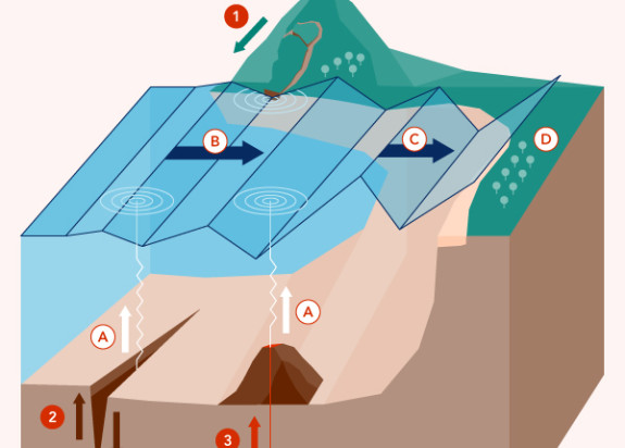
Tsunamis are usually caused by an earthquake under the seafloor. Other triggers include landslides, undersea volcanic eruptions, and meteorite impacts. These sudden disturbances cause the ocean to flow away from the disturbance, creating large tsunami waves.
In the open ocean, tsunami waves are small and can pass a ship unnoticed. As they encounter shallow water, they increase in height. Tsunamis are not just moving lumps on the ocean’s surface, they also include hollows. Sometimes the hollow reaches the coast first. When this happens, the ocean first draws back, sucking water away from coastline. It then rushes in with enormous speed and force as the lump arrives. In low-lying coastal areas, tsunamis can travel a long way inland.
A tsunami wave is not just seawater. It picks up debris as it moves, which gives it added destructive power. A retreating tsunami wave can cause as much damage as the initial forward surge.
Tsunami warning systems
For tsunamis coming to New Zealand from across the Pacific, we receive a warning from the Pacific Tsunami Warning Centre in Hawaii. Our National Emergency Management Agency (NEMA) is responsible for evaluating the danger to New Zealand and issuing national or regional warnings. Tsunamis from South America, Alaska and Japan take more than 12 hours to reach New Zealand, giving authorities time to make decisions.
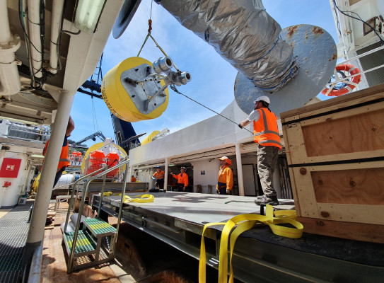
For tsunamis generated by regional earthquakes, we have a monitoring system which uses a network of offshore DART systems. Deep-ocean Assessment and Reporting of Tsunami (DART) systems are deep-ocean instruments that help detect potential tsunami-generating events in the Southwest Pacific. They also provide rapid information when no tsunami has been generated after a large earthquake, an under-sea landslide, or an under-sea volcanic eruption.
Our analysts at the 24/7 National Geohazards Monitoring Centre (NGMC) use data from the buoys and other instruments such as seismometers to help calculate the location of the earthquake and the likelihood of a tsunami happening along our coastlines. They notify NEMA who issues a tsunami warning if needed. The data from our DART systems also feeds into the Pacific Tsunami Warning Centre to prepare our Pacific neighbours for the arrival of a possible tsunami on their shores.
We also have tsunami gauges located around the coast of New Zealand to confirm the occurrence of a tsunami and record its characteristics. The GeoNet website displays the latest tsunami gauge recordings.