2010 National Seismic Hazard Model - NSHM
Database
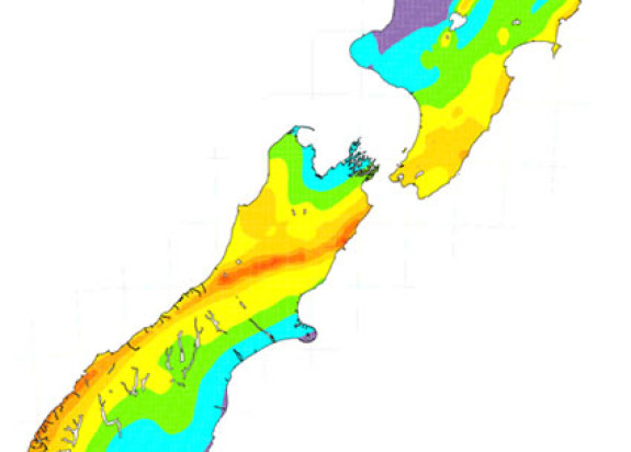
This model provides probabilistic estimates of the strength of earthquake shaking that can be expected according to a user-defined time period and probability, e.g. the peak ground acceleration (PGA) that has a 10% chance of happening in any 50 year time window.
Overview
Probabilistic Seismic Hazard Analysis (PSHA) uses the location, recurrence behaviour, and predicted ground motions of earthquake sources to estimate the hazard at a site, or across a grid of sites as shown in the map below for Class C (shallow soil) site conditions.
The NSHM is an algorithm that draws upon several component models to calculate its results. It uses a fault model that combines New Zealand’s active fault database, which includes 536 fault sources, and the 170 year historical earthquake catalogue. The background model is comprised of a multi-layered background seismicity grid.
Ground Motion Prediction Equations (GMPEs) are also an important component of the NSHM. The standard GMPE in use in New Zealand outside of the Christchurch region is the McVerry et al. (2006) GMPE.
This model has been included in the Global Earthquake Model (GEM) Foundation’s global model mosaic(external link).

-
How to read the files
Fault Source Model (file = F*.DAT)
Rows 1-3: Ignore
Row 4: Abbreviated fault source name and slip type
rv, rs = reverse
sr = strike-slip and reverse
ss = strike-slip
sn = strike slip and normal
nn, ns = normal
nv = normal-volcanic
if = subduction interface
Row 5: Number of digital straight-line sections (n) making up the source
Row 6: Dip, dip direction, depth to base, depth to top
Row 7: Endpoints of fault source in degrees and mins, characteristic Mw, and mean/preferred recurrence interval
Rows 8 to (8+n-1): Endpoints of digital straight line sections making up fault source (one row per digital section)
Row 8+n-1: End of fault source delimiterBackground Source Model (File = NZBCK*.txt)
Row 1:
Columns 1-6: Three “subcatalogues”, giving min magnitudes and time periods of completeness; i.e.
4.0 46 = M>4.0 for the time period 1964-2009 inclusive
5.0 24 = M>5.0 for the time period 1940-1963 inclusive
6.5 100 = M>6.5 for the time period 1840-1939 inclusive
Column 7: Magnitude increment (0.1)Rows 2 to end of file:
Columns 1-3: “Nvalues” for the three subcatalogues above, i.e.
N(M>4 for 46 years) N(M>5 for 24 years) N(M>6.5 for 100 years)
Column 4: b-value
Column 5: Maximum magnitude for point source
Column 6*: Percentage crustal events
Column 7: Slip type (same as fault model, listed above)
Column 8*: Percentage slab events
Column 9*: Percentage interface events
Column 10-12: Latitude, longitude, and depth of point source. Note that the point sources are spaced evenly in lat, lon, and depth, and the N values are defined for a volume that has boundaries equidistant between the point source and the immediate neighbours.* The values in these columns should sum to 1 (100%).
-
Downloads
Download source model files:
Download a version of these models formatted for OpenQuake (ZIP, 532 KB)
Cite as: Stirling, M.W.; McVerry, G.H.; Gerstenberger, M.C.; Litchfield, N.J.; Van Dissen, R.J.; Berryman, K.R.; Barnes, P.; Wallace, L.M.; Villamor, P.; Langridge, R.M.; Lamarche, G.; Nodder, S.; Reyners, M.E.; Bradley, B.; Rhoades, D.A.; Smith, W.D.; Nicol, A.; Pettinga, J.; Clark, K.J.; Jacobs, K. 2012 National seismic hazard model for New Zealand : 2010 update. Bulletin of the Seismological Society of America, 102(4): 1514-1542; doi: 10.1785/0120110170
Find more content related to:
GNS Science topics
Locations
- Whakatū / Nelson
- Rangitāhua / Kermadec Islands
- Rēkohu / Chatham Islands
- Rakiura / Stewart Island
- Murihiku / Southland
- Ōtepoti / Dunedin
- Ōtākou / Otago
- Ōtautahi / Christchurch
- Waitaha / Canterbury
- Kaikōura
- Te Tai Poutini / West Coast
- Te Tauihu-o-te-waka/ Marlborough
- Aotearoa / New Zealand
- Te Tai-o-Aorere / Tasman
- Te Whanga-nui-a-Tara / Wellington
- Manawatū-Whanganui
- Central Plateau
- Taranaki
- Te Matau-a-Māui / Hawke's Bay
- Te Tai Rāwhiti / Gisborne
- Te Moana-a-Toi / Bay of Plenty
- Waikato
- Tāmaki Makaurau / Auckland
- Te Tai Tokerau / Northland