Gravity Survey Data
Database
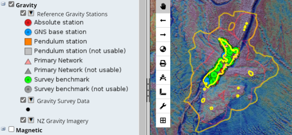
GNS Science has assembled a catalogue of over 40,000 gravity survey observations in New Zealand, including free air, Bouguer and isostatic gravity anomalies. An interactive map, as well as CSV and Shapefiles datasets, are available via E Tūhura – Explore Zealandia.
Overview
These data have been assembled from survey measurements mostly made by Geophysics Division, Department of Scientific and Industrial Research, (now GNS Science) since the 1940s using a variety of meters. Some gravity data has been contributed by petroleum explorers and universities. In 2004 all data were uniformly reprocessed using GNS Science software and tied to primary gravity sites the New Zealand Reference Gravity Stations.
Data is available via E Tūhura – Explore Zealandia. Once you have selected "gravity" from the menu, you will see Gravity Survey Data as an item. There is a pull-down menu between the tick box and the “Gravity Survey Data" title that will allow you to export CSV or Shapefile data.

Find more content related to:
GNS Science topics
Locations
- Whakatū / Nelson
- Rangitāhua / Kermadec Islands
- Rēkohu / Chatham Islands
- Rakiura / Stewart Island
- Murihiku / Southland
- Ōtepoti / Dunedin
- Ōtākou / Otago
- Ōtautahi / Christchurch
- Waitaha / Canterbury
- Kaikōura
- Te Tai Poutini / West Coast
- Te Tauihu-o-te-waka/ Marlborough
- Aotearoa / New Zealand
- Te Tai-o-Aorere / Tasman
- Te Whanga-nui-a-Tara / Wellington
- Manawatū-Whanganui
- Central Plateau
- Taranaki
- Te Matau-a-Māui / Hawke's Bay
- Te Tai Rāwhiti / Gisborne
- Te Moana-a-Toi / Bay of Plenty
- Waikato
- Tāmaki Makaurau / Auckland
- Te Tai Tokerau / Northland