Aerial aquifer mapping takes off in Tairāwhiti
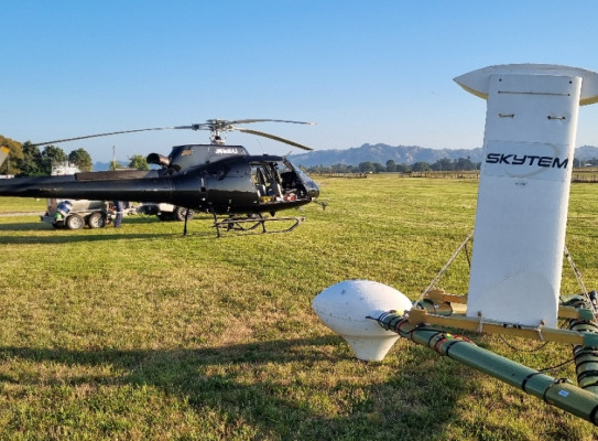
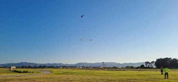
A helicopter has taken to the skies in Tairāwhiti with a large hexagonal loop suspended below, gathering information about the groundwater beneath the surface that will be used to support the freshwater resilience of the region.
The survey uses state-of-the-art SkyTEM aerial electromagnetic technology. The electromagnetic scans, combined with existing data, will provide a three-dimensional picture of the region’s aquifers (locations where water is naturally stored underground). In addition to uncovering the depth and size of aquifers, it will provide insights into how the aquifers connect to wetlands, lakes, streams and the ocean.
Aqua Intel Aotearoa is working with Gisborne District Council to deliver the survey, in discussion Te Runanganui o Ngāti Porou, Tāmanuhiri Tūtū Poroporo Trust, Te Aitanga a Māhaki Trust and Rongowhakaata Iwi Trust. The Aqua Intel Aotearoa programme studies regional water availability and storage and is delivered in partnership between GNS Science and Kānoa - Regional Economic Development and Investment Unit, funded through the Provincial Growth Fund.
Aerial surveys will be conducted throughout February around Wharekahika/Hicks Bay, Te Araroa, Waiapu and Tolaga Bay before moving to the Poverty Bay flats. GNS Science Hydrogeology and Geophysics Team Leader Stewart Cameron says there is limited existing knowledge about the aquifers north of Gisborne.
The survey flights and associated data collection will build our understanding of groundwater in the region, particularly regarding how the groundwater and surface water interact, and how the aquifers are replenished. This is vital knowledge to ensure that this precious resource can be appropriately managed and protected.
Aqua Intel Aotearoa Programme Director Jane Frances says the information being gathered will help plan for greater resilience to extreme weather events through, for example, identifying potential future sources of drinking water.
“The Government’s investment in this project is intended to provide high-quality science and the data to help understand how to protect and use land and water in order to improve the wellbeing of wai, whenua, and whānau,” says Frances.
Alongside the aerial surveying, Aqua Intel Aotearoa are working with Gisborne District Council to drill a number of bores that will provide detailed information in specific locations, which will be analysed with the SkyTEM data to help build an understanding of the geology and groundwater system. The work programme also includes groundwater chemistry sampling, and measurement of stream flow.
Over the coming months, GNS Science scientists will work to interpret and analyse the data.
“The strength of the aerial mapping technology is that it can cover large areas of ground quickly and cost-effectively, providing detailed data to several hundred metres below ground. This geophysical dataset combined with other information, such as data from groundwater bores, helps to create 3D aquifer maps and models that can inform groundwater management decisions,” says Cameron.
The Tairāwhiti survey is part of an extensive programme of groundwater mapping, with aerial surveys already carried out in Hawke’s Bay, Wairarapa, Northland and Southland. This work aligns with GNS Science’s wider aim to increase the availability and security of clean water for Aotearoa.
The SkyTEM data allows us to characterise our groundwater systems so that they can be well managed. This will ensure that we don’t overuse or damage a resource that’s only going to become more critical as the climate changes.
-
Project funding
The Tairāwhiti survey is primarily funded by the Government through Aqua Intel Aotearoa, with a contribution from Gisborne District Council. International specialists SkyTEM Australia and a New Zealand helicopter company are flying the survey.
-
SkyTEM technology
Aerial electromagnetic surveying involves flying over the land with a loop system suspended from a helicopter. Transmitters send electromagnetic signals underground, and sensors measure the behaviour of the returning signals. Similar to radar, we can ‘see’ what’s under the ground by analysing the way the signals return. It is sensitive to rock type, porosity, permeability, clay content, moisture content, and properties of water such as salinity, all of which help in understanding aquifers and contribute to mapping and characterisation of aquifers.
The technology is safe for people and animals. Because the helicopter is moving at high speed, there’s very limited exposure to the electromagnetic signals. It’s safer than watching an LCD or plasma TV or blow-drying your hair.
This is a safe and effective measurement tool that is used around the world and has already been used to survey aquifers in Northland, Hawke’s Bay, Wairarapa and Southland.