Aerial aquifer survey lands crucial insights for Hawke’s Bay’s freshwater resilience
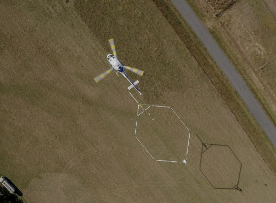
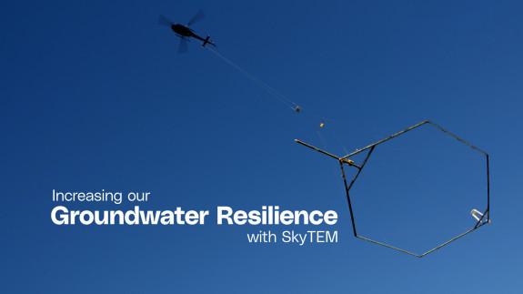
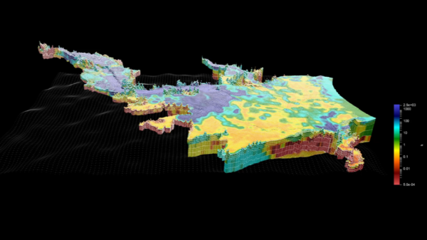
In 2020, a helicopter with a large hexagonal loop suspended below took to the skies in Hawke’s Bay, gathering information about the vast groundwater system beneath the surface. GNS Science and Hawke’s Bay Regional Council have completed analysis of 8,000 kilometres of data, creating three-dimensional models of the region’s underground aquifers, and tools to inform the Council’s water management policies.
In 2020, a helicopter with a large hexagonal loop suspended below took to the skies in Hawke’s Bay, gathering information about the vast groundwater system beneath the surface. GNS Science and Hawke’s Bay Regional Council have completed analysis of 8,000 kilometres of data, creating three-dimensional models of the region’s underground aquifers, and tools to inform the Council’s water management policies.
Groundwater is critical for our freshwater security. In the Hawke’s Bay, as in many other regions, it is relied on for drinking and irrigation. Understanding the extent of the aquifers below ground, and how they interact with surface water is key for effective freshwater management.
The Hawke’s Bay survey used state-of-the-art SkyTEM aerial electromagnetic technology. The electromagnetic scans provide a very accurate picture – to an average depth of 300 m - of the aquifers and their properties such as where water is stored and how it flows underground. GNS Science Senior Hydro-geophysicist Zara Rawlinson says that the level of three-dimensional detail has exceeded expectations.
"This high-resolution spatial detail, combined with existing borehole data such as the age of groundwater, has significantly improved our understanding of the region’s aquifer systems," says Rawlinson
This is vital information to support the sustainable management of Hawke’s Bay’s freshwater.
The data has been used to update numerical groundwater models for the Heretaunga Plains, Ruataniwha Plains and a more localised Bridge Pa model, that are the primary tools used by the regional council to aid in setting groundwater allocations and other management decisions. The SkyTEM data helped to refine these models and reduce the uncertainty of simulated parts of the system that are critical for sustainable managements decisions, such as river flows and groundwater levels.
Hawke’s Bay Regional Council Team Leader - Hydrology and Groundwater Science, Simon Harper, says the technology greatly improves understanding of the region’s aquifers.
“We expect that businesses and the public will benefit from this comprehensive dataset now that it is available. How it is used and the benefits going forward will no doubt evolve as our technical and scientific communities build on this work,” says Harper.

The new models will help the Council make better policy and rules to balance the water demands of industry and agriculture, while not adversely impacting the health of our aquifers.
The study provides vital information that can help reduce contamination risk, with drinking water security a key priority for the region following the 2016 Havelock North Campylobacter outbreak.
“We’ve refined the mapping of the near-surface clay-rich layer of the aquifer, which helps us understand the vulnerability of the groundwater system to surface contamination. The models can be used to improve our knowledge of how contamination flows through the system, and to help define source protection zones for drinking water wells,” says Rawlinson.
The helicopter-borne technology is a game-changer for groundwater data collection.
“SkyTEM provides an efficient and cost-effective way to gather information over large areas—it’s like having hundreds of thousands of wells at a fraction of the cost,” says Rawlinson.
Hawke’s Bay was the first regional council in the country to map its aquifers using SkyTEM. Building on this innovative work, GNS Science has partnered with other organisations to undertake similar work programmes in Northland, Wellington, Gisborne and Southland.
“We’ve now collected close to 29,000 kilometres of data across New Zealand, working closely with partners in each region to understand what their priorities are, so that we can produce models and outputs that are fit-for-purpose,” says Rawlinson.
Funding for the Hawke’s Bay survey included $300k from GNS Science, $2.4m from Hawke’s Bay Regional Council and $2m from the Provincial Growth Fund administered by Kānoa – Regional Economic Development and Investment Unit (Kānoa – RD).
This is a great example of local and central government agencies working together to support a critical project in the region, says Kay Read, General Manager Regions for Kānoa – RD.
“It’s fantastic to see this significant mapping work completed and available for public use. By gaining detailed insights into our water resources, the region can better improve its resilience to droughts and support economic productivity,” says Read.
GNS Science and Hawke’s Bay Regional Council have worked together to develop an online interactive storymap(external link) making the three-dimensional models accessible to the public. The datasets are also available for more technical users through the GNS Science Dataset Catalogue(external link).
-
SkyTEM - how does it work?
Aerial electromagnetic surveying involves flying over the land with a loop system suspended from a helicopter. Transmitters send electromagnetic signals underground, and sensors measure the behaviour of the returning signals. Similar to radar, we can ‘see’ what’s under the ground by analysing the way the signals return. It is sensitive to rock type, porosity, permeability, clay content, moisture content, and properties of water such as salinity, all of which help in understanding aquifers and contribute to mapping and characterisation of aquifers.