Dunedin research forecasts groundwater challenges as the sea level rises
A new report from GNS Science reveals important insights for coastal communities with shallow groundwater, shedding light on the need to plan for some of the lesser-known impacts of sea-level rise, such as the loss of capacity for the ground to absorb rainfall, and flooding from groundwater emerging at the surface.
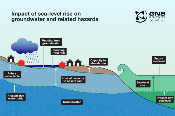
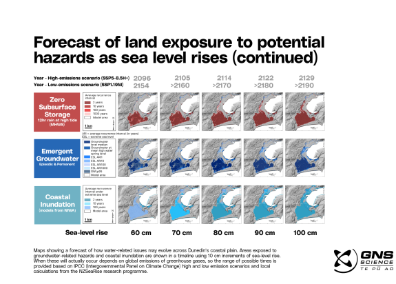
As our sea levels rise due to climate change, it’s expected the water table (upper surface of the hidden water underground) will also rise in areas near the coast where groundwater is shallow and the ground is permeable (allows the flow of water through it). Impacts may include inundation of stormwater and wastewater systems, building instability and increased liquefaction vulnerability. Eventually groundwater can emerge at the surface as springs and cause localised flooding.
The GNS Science study, Dunedin groundwater monitoring, spatial observations and forecast conditions under sea-level rise, produced in partnership with Otago Regional Council (ORC), provides vital information on the behaviour of groundwater beneath the Dunedin suburbs of South Dunedin and Harbourside. It forecasts when and where groundwater-related hazards, such as increased flooding from rainfall and flooding from below, are likely to occur.
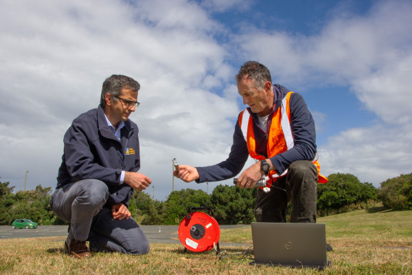
Based on analysis of four years of data from the ORC-operated groundwater monitoring network in South Dunedin and Harbourside, the research looked at what causes change to groundwater levels, such as tides, storm surge and rain, and used modelling to understand how sea-level rise will alter the future fluctuations and elevation of groundwater levels.

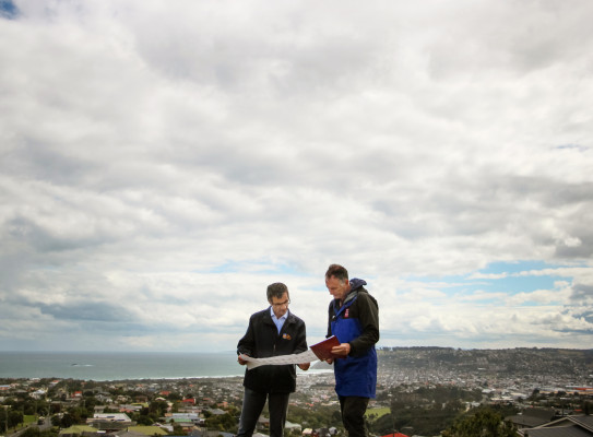
GNS Science Principal Scientist Simon Cox says, “The flat-lying coastal land of Harbourside and South Dunedin is vulnerable to effects from the harbour and ocean."
Our study shows that in some areas, as the sea level rises, groundwater will contribute to flood problems in two ways – through loss of the ground’s capacity to store rain, and then flooding from below. This can be expected before any inundation directly from the sea.
The research will help to inform the South Dunedin Future programme – an ORC and Dunedin City Council partnership that tackles climate change, sea-level rise and flooding problems in South Dunedin.
Otago Regional Council Manager Natural Hazards Jean-Luc Payan says, “This unique research is key to understanding the complexity of what’s happening under the ground in South Dunedin and Harbourside. It builds on monitoring work ORC and GNS have been doing together since 2009, and provides a detailed picture of where and when issues will arise. This helps us to understand how hazards will evolve and enable planning for the future.”
It’s an important tool in determining adaptation options for the future of South Dunedin.
The forecasts of the groundwater-related impacts are mapped against 10 cm increments of sea-level rise, with estimated timeframes provided based on IPCC (Intergovernmental Panel on Climate Change) emissions scenarios.
Cox says “We know that sea-level rise is already happening but can’t be specific about the timeframe of exactly how quickly - this depends on global warming and international efforts to reduce emissions. The research shows that Dunedin needs to plan for water coming from above, below and sideways from the ocean and harbour. However, the monitoring shows the ground is less prone to tidal flow and entry of seawater than initially feared, which provides a little more time for the city to plan.”
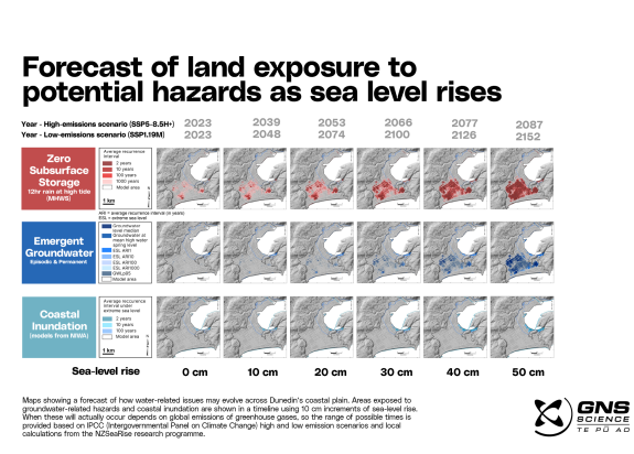
This is the first study in New Zealand, and likely internationally, to model groundwater’s contribution to multiple sources of flooding hazard. It looks at the episodic and acute hazard conditions that develop as a result of rising groundwater, rather than focusing on long-developing permanent inundation.
“Most research considers rising groundwater and ‘flooding from below’ as a long-developing permanent condition. But as the groundwater rises it affects the way rainfall flood hazard evolves, turning a previously pervious area into an impervious area, making it more prone to flooding during heavy rainfall. This study attempts to integrate and forecast all of groundwater’s contribution to flood hazards, including the episodic issues that arrive first,” says Cox.
This new understanding of the interplay of groundwater hazards will be vital for strengthening Dunedin’s climate resilience and holds important insights for other coastal areas in New Zealand that will face similar challenges in the future.
When most people think of sea-level rise, they imagine waves creeping closer to homes. Case studies like this one from Dunedin that model the other impacts that sea-level rise brings, such as rising groundwater, will help communities better plan and prepare for the future.
The NZSeaRise Te Tai Pari O Aotearoa research programme partially funded the Dunedin groundwater research. Along with improving projections of sea-level rise in New Zealand, the programme and its follow-up Our Changing Coast Te Ao Hurihuri Te Ao Hou, also aim to improve regional adaptation to coast hazards such as groundwater.
-
Project funding
The report brings together approximately $500k of national (MBIE) funding from a number of workstreams (including the GNS Strategic Science Investment Fund and the Endeavour-funded NZSeaRise programme), along with $50k co-funding from ORC.
-
Dunedin groundwater monitoring network
A relatively simple monitoring network installed across Dunedin provides useful new information on the behaviour of coastal groundwater. Dunedin’s groundwater monitoring network now comprises 35 sites across South Dunedin and Harbourside. Water temperature and pressure are measured by automated sensors every 15 minutes, and observations of salinity are made regularly to see the amount of sea-water present. The data provides information on how water beneath the city responds to rainfall, seasonal variation, hillslope runoff, pumping, the effect of tides, and inland flow from the sea.