GNS leads international voyage to better understand cause of Hunga volcano eruption

GNS Science is leading a month-long international voyage to undertake the most comprehensive post-2022 eruption surveys of the Hunga submarine volcano to date to better understand what caused the powerful eruption and what this can tell us about the submarine volcanoes in New Zealand’s own maritime estate.
Voyage leader and GNS Scientist Cornel de Ronde said the violent eruption of Hunga volcano was a timely reminder to both the volcanology community and civil defence authorities of just how devastating these super eruptions can be and how little is known about why they occur.
“The new data to be collected during the upcoming cruise will fill in many blanks and provide context for future studies with an eye to being able to better predict when these eruptions might occur given New Zealand has several volcanoes similar to Hunga within our Exclusive Economic Zone,” Dr de Ronde said.
A recently released study in the international Journal of Volcanology and Geothermal Research proposes the powerful eruption was caused by a gas-driven climactic explosion rather than a phreatomagmatic one (where magma and water react violently) as previously thought.
To further investigate the evidence supporting this theory the expedition from 15 May to 12 June onboard the R/V Tangaroa will collect geological, geophysical, and water column data inside the volcano crater and over the flanks of the submerged eruption vent (more details below).
Dr de Ronde said seafloor sampling and surveys undertaken by the uncrewed British surface vessel Maxlimer in the aftermath of the eruption provided evidence that the magnitude of the eruption was much greater than could possibly have been triggered by a water-magma reaction alone.
“In modern geoscience it is insufficient to define a mechanism without any level of quantification or consideration of basic and well-established principles of physics and chemistry,” Dr de Ronde said.
“As we cite in the paper, many workers in the field of 'phreatomagmatic' eruptions have noted the limitations on heat transfer between water and rock that relate to the low thermal conductivity of rock material and the limitations of surface area.
“Our approach does not deny the presence of a magma system beneath the volcano that streams reactive gas to develop the distal gas seal. We then provide a mechanism for the explosion and subsequent excavation of the crater. The caldera collapse speculation does not define a triggering mechanism or integrate with the quantitative data for the energetics or the time sequence of the eruption.”
GNS lead international voyage to study cause of Hunga volcano 2022 eruption
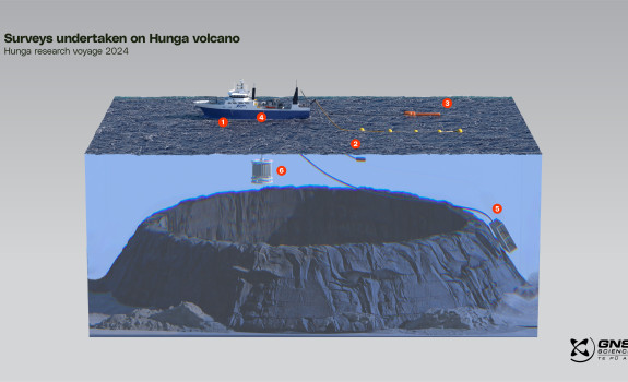
- Multibeam survey – uses sonar to map the seafloor and detect objects in the water column.
- Seismic streamer - detects the very low level of reflection energy that travels from the seismic source through the water layer to the earth and back up to the surface, to reveal the architecture of the volcano.
- Magnetometer - measures magnetic field strength to uncover regions in the volcano where hot fluids have altered the rocks and weakened them.
- Gravimeter - detects subtle changes in gravity caused by magma movements.
- Rock dredge - collects fresh and altered rock samples from the volcano to provide insights into its history and age and surrounding volcanic features.
- CTD – detects how the conductivity and temperature of the water column changes relative to depth to locate hydrothermal plumes and determine the extent of volcanic activity.
Multiple surveys will be conducted throughout the voyage to investigate the volcano’s anatomy and establish triggers for the eruption, such as the full depth of the crater evacuated by the eruption, the volcano’s age and history, magma conditions over time, characterisation of the hydrothermal system initiated since the eruption, and to ascertain if there is any ongoing activity for future hazard assessment.
“This will be the first voyage to Hunga that will comprehensively map the seafloor while also measuring the gravity and magnetic signatures of the remaining edifice. When combined with seismic surveys to detail the inner architecture of the volcano and the recovery of rock samples to elucidate the volcanic evolution of volcano, with water column surveys to determine ongoing hydrothermal and/or volcanic activity, the essential framework for studies done to date and into the future will now be in place,” Dr de Ronde said.
Seafloor mapping of the Kermadec Ridge will also take place during transit to and from Hunga to add to the bathymetry database of this region.
The voyage will include researchers from GNS Science, University of Auckland, Natural Resources Tonga, University of Genova, National Oceanic and Atmospheric Administration, GEOMAR Helmholtz Centre for Ocean Research Kiel, University of Toronto, and the Queensland University of Technology.
“The breadth of the nations represented on the cruise highlight the global significance of the work being done and the importance of this research to the wider scientific community.”
GNS Science’s contribution to the voyage has been funded by the Beneath the Waves Endeavour programme, MBIE Strategic Science Investment Fund, Large Experiment Investment Fund and GNS vessel time allocated by the Tangaroa Reference Group.
* Banner image photo credit: Pununu Tukuaufu - Tonga Geological Services