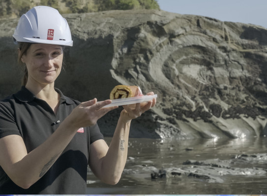
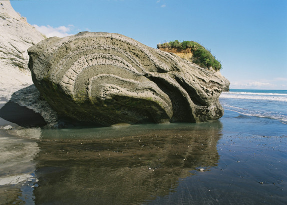
Jam roll or ancient underwater landslide?
How can a virtual field trip include not just excellent science, but the experience of being out on location? GNS Science’s Malcolm Arnot and Suzanne Bull decided to give it a try - and the results are a mix of science, travelogue and impressive drone shots, with the odd cake thrown in.
As with many other plans in 2020, conference organisers found themselves stuck when long-anticipated events had to be cancelled – or found another way to deliver them. In the case of the Ninth International Symposium on Submarine Mass Movements and Their Consequences (known by its attendees as ISSMMTC), a planned conference in Dublin was postponed and the entire event moved online.
The challenge for organisers and attendees alike: how to recreate not just the content of a conference, but the experience as well? Geoscience conferences aren’t just about presentations and networking, but also about opportunities to get out into the field – and these conferences regularly involve trips to local sites of interest.
Suzanne says she was first contacted in February about the need to recreate that experience.

Our conference convener, who’s a friend of mine, hadn’t left her flat in Brighton for months. There was an incredibly critical need, and we just felt we had to do it because almost no-one else in the world could
Suzanne and Malcolm – ably assisted by drone pilot Andrew Boyes and videographer Dave Allen – headed up to Taranaki to explore onshore evidence of historic submarine landslides. But the video segments are about much more than that. They cover the journey, the stop in Bulls for a cup of tea, a few unexpected encounters along the way – and a lot of laughs.
The videos are incorporated into a map-based storytelling environment, which also features 3D models of the outcrops and will allow visitors to “explore” the sites at their own pace.
Both Suzanne and Malcolm see huge potential for virtual field trips – opening up sites and geological features that might not otherwise be possible to access.
“We want people to have a sense of what it’s like being in the field, but also to feel that sense of being with other people on the journey,” Suzanne says. “We’ve embedded a tool called Padlet and you can post a comment and see what everyone else is saying. You get a sense of community that you didn't do this alone, you’re there with your peers. We’ve really tried to take this from the physical world into the virtual world.”
The COVID-19 pandemic has accelerated the need for new digital learning models, and it’s forced scientists and research agencies to get creative with how they convey complex concepts in a virtual model. As Malcolm puts it, “you can’t replace actually going out and licking the rocks, but this digital and virtual approach complements that – and in the current situation it’s pretty much essential.”
“Digital media is accessible, reusable and flexible,” Suzanne adds. “In tandem, there is increasing demand for science to be communicated in more diverse ways and to be ever more engaging and interactive. This has been a great opportunity to learn what it takes to produce a virtual geoscience experience.”