M7.8 Kaikoura quake the biggest since the Dusky Sound jolt in 2009
Scientists continue to pore over seismic, satellite and GPS data to try and understand the complexities of the magnitude 7.8 earthquake that occurred in North Canterbury on Monday morning. It is the biggest quake in New Zealand since the magnitude 7.8 Dusky Sound earthquake in 2009.
Named the Kaikoura earthquake, scientists are describing it as a complex rupture sequence that produced ground-shaking that lasted for about two minutes and was felt throughout the country. It was centered east of Hanmer Springs at a depth of 15km.
The most severe shaking occurred about 50 seconds after the quake rupturing started. Nearly 900 aftershocks have occurred since the main shock. They are expected to continue for months.
Most of the energy from the quakes has been directed to the north. A similar phenomena was seen with the Dusky Sound quake in Fiordland, where most of the energy was directed out into the Tasman Sea.
Like other large earthquakes in New Zealand, the Kaikoura quake appears to have involved jumping from one fault rupture to another in a complex pattern. This compound style of rupture was a feature of the magnitude 7.1 Darfield quake of 2010 where up to eight neighbouring faults ruptured almost simultaneously.
When all joined up, the fault ruptures from Monday's quake extend for about 100km. It occurred in a part of the upper South Island some scientists are describing as 'an area of knotted faults' mostly trending northeast-southwest.
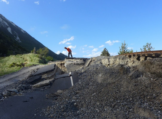
At daybreak yesterday three GNS Science geologists took to the air in helicopters to make observations of quake damage in the North Canterbury-Marlborough region.
They estimate there could be up to 100,000 quake-triggered landslides in North Canterbury and southern Marlborough. They range from small to very large. Some are on private farmland, but most are in the back country and the steep ranges.
The largest, on the south side of the Clarence River mouth, is estimated to be one million cubic meters.
Geologists are describing this as the biggest landslide in New Zealand since the Young River landslide near Wanaka in 2007.The number and distribution of landslides is considered consistent with the severity of the ground shaking.
They also observed numerous surface fault ruptures, blocked rivers, and sections of the main trunk railway line shunted sideways by many meters. Numerous landslides are blocking highways, bridges, and rail tunnels.
Over the coming days, GNS Science and GeoNet staff will deploy instruments in the quake region to gather intelligence on the aftershock sequence. This includes portable seismometers to get more precise recordings of aftershocks and GPS instruments to measure deformation of the land surface. With landslides blocking roads, they will probably need to rely on helicopter support.
On Monday GNS Science seismic engineers spent time in downtown Wellington observing light surface damage at the Port and damage to some highrise buildings.
Scenarios and probabilities
Most earthquake aftershock sequences decay over time, with spikes of activity and occasional larger earthquakes. GeoNet has issued aftershock probabilities that describe the likely progression of the sequence over the coming months.