UPDATE: New areas added to our high-resolution active faults webmap
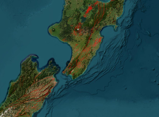
UPDATE: The Tairāwhiti Gisborne region and the northern Alpine and Wairau faults have now been added to the high-resolution layer of the New Zealand Active Faults Database webmap.
Those wanting to know where ground surface rupturing is most likely to occur in New Zealand during a large earthquake will now have even better and more detailed information thanks to an upgrade to the GNS Science New Zealand Active Faults Database (NZAFD) webmap.
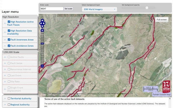
The webmap now includes a high-resolution (1:10,000 scale or better) active fault surface trace layer for some regions – 25 times greater resolution than the existing 1:250,000 scale layer available on the webmap. This means thousands more active fault traces can now be viewed right down to the property scale.
It is expected the upgrade will be particularly useful for councils but also hazard planners, infrastructure industry, geotechnical practitioners, researchers and homeowners to better understand the potential location of surface fault ruptures during future large earthquakes, at a relevant scale.
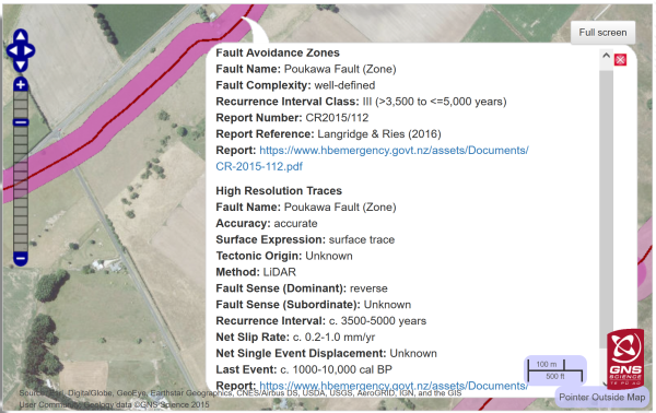
The webmap also includes Fault Avoidance Zones and Fault Awareness Areas for the high-resolution active fault layer, where available, which are important for land-use planning.
Fault Avoidance Zones delineate and mitigate areas of surface rupture hazard, through the application of the Ministry for the Environment Active Fault Guidelines(external link), while Fault Awareness Areas(external link) highlight areas where a surface rupture hazard may exist and more information is required.
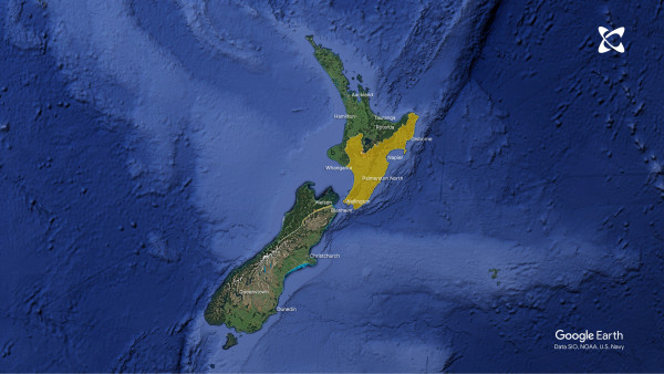
The high-resolution data is currently only available for Hawke’s Bay, Manawatū-Whanganui (Horizons), Wellington and Tairāwhiti Gisborne regions as well as the northern Alpine and Wairau faults. More areas will be added as funding permits and work progresses.
Active fault surface traces are visually identifiable at the earth surface and indicate areas prone to fault rupture during a large earthquake.
The NZAFD webmap comprises lines showing onshore active fault surface traces – defined as those that have ruptured and/or caused ground surface deformation during the last 125,000 years*. Each fault trace also includes attributes that describe the expected rupture frequency, slip rate, last known event and other parameters useful for risk assessments, where available.
Some active faults well known to people, such as the Port Hills (2011 Christchurch earthquake) and Awanui (1931 Napier earthquake) faults, do not appear on the NZAFD webmap as these are buried active faults that have not ruptured the ground surface and have no surface expression.
Users of this GNS webmap will see consistent symbology and attribute information, making it a trusted, up-to-date and consistent source of truth for active faults in New Zealand.
Other enhancements users will see are more regular updates of the existing 1:250,000 scale dataset that can be downloaded, along with more explanatory information (metadata) about each dataset and how it can be used.
While many of the high-resolution datasets are currently available on respective regional and local council digital platforms, the enhanced GNS webmap makes this information available in a single publicly accessible location accessed on a visually interactive platform.
Knowing where New Zealand’s active faults are located can help people make informed decisions about where to build and make existing infrastructure more resilient to the effects of earthquakes.
It also serves as a good reminder to prepare for earthquakes that can happen anytime. Advice on making homes safer in the event of an earthquake is available on the Natural Hazards Commission Toke Tū Ake Homeowners webpage(external link).
*Except for in the Taupō Rift, where the definition of activity is restricted to include only the last 25,000 years