New geological map helping decision makers plan for South Auckland's future

Our Science

01 December 2021

Karioitahi Beach

A new set of geological maps for some of Aotearoa New Zealand’s fastest-growing regions will help decision-makers plan for the future.

GNS Science’s urban geological mapping programme aims to provide geological information that will contribute to planning and infrastructure development in rapidly growing areas.

The digital map-sets typically include geological and geomorphological maps, a 3D geological model, and overview reports.

GNS Geologist, Julie Lee, says the more that we know about the ground beneath our feet, the better our decision makers can plan for the future.

“Geological maps for urban areas require a different approach to geological maps covering wider tracts of the country. Urban areas need to be mapped at a more detailed scale to be of benefit to people who need to understand the geological foundations of their properties, buildings and infrastructure”.

can inform land use planning and development decisions that will manage and mitigate the potential impact of these hazards

Julie Lee Geologist GNS Science
234483 Bruce Hayward Bruce Hayward
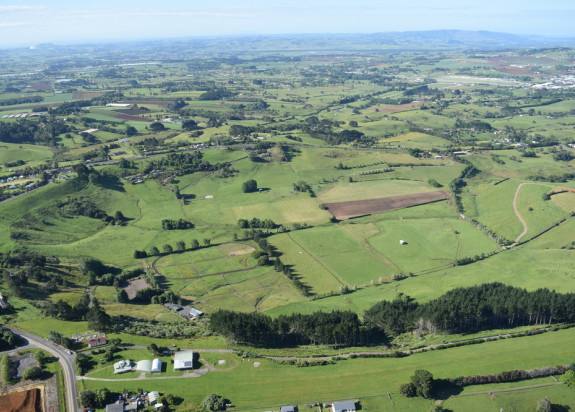
Pukekohe East crater, South Auckland Volcanic Field. Credit: Bruce W Hayward

“The maps also provide a perspective on the geological hazards in a town or city and can inform land use planning and development decisions that will manage and mitigate the potential impact of these hazards”.

“They also increase our ability to understand, plan, and care for significant natural landscape features, and inform how we utilise geological resources such as aggregate and groundwater”.

Updated urban geological map information for Christchurch was completed in 2015, and a similar map for Napier-Hastings was issued in 2020. A new map for the area surrounding Pukekohe is nearing completion and is due to be released next year.

This latest map covers 830 square km of the rapidly growing Pukekohe area – including Papakura in the north to Pōkeno in the south, out west to Waiuku, and to the Hunua Ranges in the east.

The previous geological map of the region is nearly 30 years old and the new map is a timely addition to geological knowledge. It revises and updates rock classifications and combines recently captured aerial mapping image data with Geographic Information Systems software.

Another Auckland map – covering Silverdale to Warkworth – will be the next product in this urban series. Throughout the production process we involve stakeholders and end-users such as geotechnical consultants, councils and universities.

SA maps
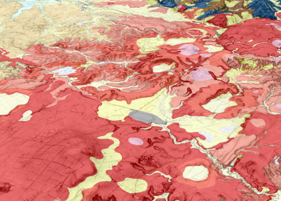
A 3D perspective view of the many volcanic features around the Pukekohe-Bombay area, including explosion craters, tuff rings, lava flows. Credit: Julie Lee, GNS Science
Henrys Stuart 1350

Stuart Henrys Principal Research Geophysicist

Stuart is the Land and Marine Geoscience Theme leader and coordinates national and international geoscience research initiatives, many of which are delivered in partnership with government agencies, CRIs, universities, and iwi/Māori. The primary focus is on the generating new ideas and knowledge, which underpins all of GNS’ Earth Science disciplines. Stuart’s key areas of input and influence is in understanding the processes that shape Te Riu-a-Māui Zealandia helping New Zealand Improve predictive capability for geological hazards, understand global-scale and deep-time environmental change variability and impacts, and identify new sustainable natural resources. He is the Chair of GeoDiscoveryNZ which coordinates our membership in global scientific drilling in partnership with the International Ocean Discovery Program (IODP) and the International Continental Drilling Program (ICDP).

View Bio Contact Me
By continuing with this download you agree to abide by the rules laid out in the Terms and conditions/Terms of use listed on this page.

If there are no specific Terms and conditions/Terms of use listed then please refer to our Copyright and Disclaimer page and Privacy Policy page

Download