New geological map unveils details on faults, landslides, and extinct volcanoes in the Pukekohe area of South Auckland
GNS Science has released the latest map from the New Zealand Urban Geological Mapping Project.
The mapping unveiled new details on faults, landslides, and extinct volcanoes in the area.
GNS Science communications would like to dedicate this news item to Dave Young.
Deeper insights into the geology of Pukekohe, Papakura, Waiuku, Pōkeno, Bombay, Drury and Hunua
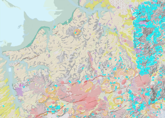
Today GNS Science is releasing new research findings, and a geological map for part of South Auckland centred around the town of Pukekohe. The ‘Geology of the Pukekohe area’ is a new 1:50,000 geological map, covering 830 km² from the southern shoreline of Manukau Harbour to the lower Waikato River. Users can also access a 3D geological model of the data.
The research is a part of the Urban Geological Mapping Project led by GNS Science and funded by the New Zealand Government. This is the first detailed geological map of this area in nearly 30 years.
The availability of modern-day, high resolution digital datasets has helped GNS experts identify and locate more accurately landform features such as landslides, fault lines, and extinct volcanoes. The mapping was primarily a desktop research compilation.
Better understanding of faults in Waiuku, Pukekohe, Pōkeno and Drury
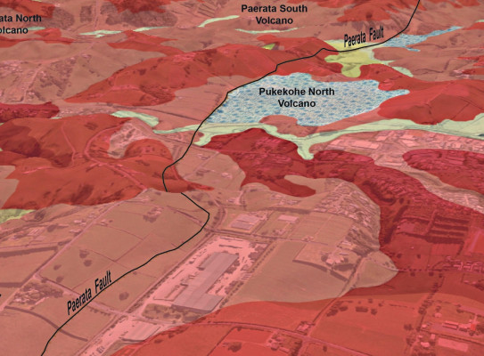
Our GNS experts have now more accurately defined geological faults in the region. Our current understanding from the data is that there are 3 ‘active’ and 12 ‘possibly active’ faults in the area.
The active faults identified are the “Pukekohe (Waiuku) Fault”, the “Paerata Fault” and the “Aka Aka Fault”. Although faults in this area are not new, and most have been previously inferred, this is the first time they’ve been mapped at the modern land surface and in such detail.

This improved understanding of not only the faults’ locations, but also their activity, has allowed them to be specifically incorporated into the new (recently released) revision of the New Zealand National Seismic Hazard Model. This is the first time that faults in this particular area have been specifically included in a national-scale model, increasing our awareness of seismic hazard in the region. Although research into fault activity is ongoing, initial assessments suggest that these faults have low levels of seismicity.
Several hundred more pre-historical landslides found
This project used LiDAR data captured between 2013–2018 to map landslides in the area and do not represent landslides from recent storm events. LiDAR (Light and Detection Ranging) data provides detailed information about the height, shape and form of the land surface.
The geology map depicts around 800 areas of past (mainly prehistoric) landslide movement, predominantly in the foothills of the Hunua Ranges east of Drury, but several were also found in the downlands around Tuakau-Pōkeno-Pukekohe. These landslides are characterised by hummocky/undulating and sloping ground, often with a steep scarp or step at the top of the slope.
As this mapping has revealed more “old” landslides, we now have a better understanding of the factors that contribute to landslides in the map area and therefore this knowledge can better inform future risk assessments. While the new mapping does provide more robust information to aid site-specific investigations, the geological map and data are not a replacement for those investigations.
This new information on landslides will be incorporated into the New Zealand Landslide Database hosted by Auckland Council and GNS Science's landslide databases.
We now know more about the Pukekohe’s volcanic history
Several distinctive landform (geomorphic) features suggest previously unidentified eruptive centres within the South Auckland Volcanic Field. We have now differentiated lava flows, volcanic cones and explosive tuff rings and craters separately, as well as areas of thick overlying volcanic ash (tephra) deposits. Several more centres have been recognised and this provides a new appreciation for the complexity of the volcanic field.
These maps significantly contribute to the understanding of New Zealand's geology and geohazard risks.
The more accurate locations and definitions of these faults and landslides will provide a context to help community decision-makers and local government make planning decisions about how to better manage the risks. This new mapping gives us a better understanding of the iconic landscape features that comprise the South Auckland Volcanic Field.

The data from these maps will be a valuable and up-to-date resource for geologists, planners, and geotechnical practitioners, as well as the Auckland and Waikato District councils. The data will be used to support a wide range of applications, including planning, geological hazard and risk assessment, and environmental management.
-
What types of information are shown in the maps?
The products being developed for the Pukekohe area include three main types of information - A 2D geological map, a digital 3D model that shows the geology hundreds of metres beneath the land surface, and a landform map showing the shape of features formed by rivers, wind, volcanic eruptions, and the sea.
-
How were these maps created?
The new maps and 3D model integrate conventional 2D surface mapping with subsurface information obtained from New Zealand Geotechnical Borehole Database (NZGD) drill holes, geotechnical probes, geophysical data, and LiDAR data.
LiDAR technology (Light Detection and Ranging) is a remote sensing technique that obtains high-resolution 3D information of the shape of the land surface. The data obtained provide our scientists with more precise topography from which you can better interpret features such as faults.
Regional capture of LiDAR data has occurred only in the last 10 years. This project has enabled those data to be analysed by GNS experts.
-
Where can these maps be found?
These maps can be obtained through the GNS website here.
Landslide, fault and geology information will also be available through the Auckland Council website.
-
What is the Urban Geological Mapping Project?
This project helps New Zealand make informed decisions about how they utilise and manage resources like aggregate and groundwater, how they might be affected by geological hazards and how they approach issues like planning and development. Urban geological maps provide improved understanding of the geological foundations of properties, buildings and infrastructure and the materials that may be encountered below the surface.
This project is led by GNS Science and is funded by the New Zealand Government.
Find more content related to:
GNS Science areas
- Te Riu-a-Māui Our Continent
- Volcanoes
- Our Changing Landscape
- Our Natural Resources
- Building Resilience