View Bio
New map shows Lake Rotomahana in more detail than ever
A new map of the lake floor of Lake Rotomahana is the first new bathymetric map of the lake in 40 years and represents nearly a decade of data gathering by GNS Science and American partners.
Its resolution is 400 times better than the previous map and it shows many geological features not seen before, including the Pink and White Terraces.
“The new map helps put all existing information about the 1886 Mount Tarawera eruption and the geothermal systems under Lake Rotomahana into a much better context,”

It shows lake floor features and other subtleties that have not been seen for more than a century, before the lake started to fill up immediately after the 1886 eruption.
It also shows the likely locations of the remnants of the Pink and White Terraces, with the White Terraces largely destroyed during the 1886 eruption and the Pink Terraces having survived in part
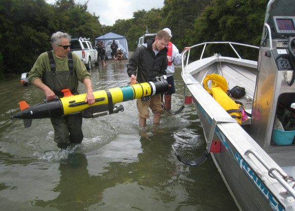
Multi-beam sonar was used to provide a highly detailed view of the lake floor topography, or bathymetry. To delve even deeper into the 6km by 3km lake, scientists used a seismic reflection technique to effectively ‘strip off’ the recent sediments deposited into the lake and reveal the surface of the lake floor immediately after the eruption.
Scientists also made measurements of magnetic and heat flow anomalies which show the distribution of different rock types, where hydrothermal fluids would have upwelled prior to 1886, and where hot water is being discharged into the lake today.
The lake increased five times its original size after the 1886 eruption, which covered the surrounding countryside in mud and ash up to 40m thick. The blast was so violent, it could be heard as far away as Auckland and Christchurch.
Post-Treaty-settlement iwi governance entities Tūhourangi and Ngāti Rangitihi say they are delighted with the new map and what it depicts.
“The map is significant in that it locates the sites of Ōtūkapuarangi (The Pink Terrace) and Te Tarata (The White Terrace),”
Bay of Plenty Regional Council, which has supported GNS Science in bathymetric and geophysical surveys of Rotorua lakes, has also given the map its seal of approval.
The information GNS Science portrays in its Lake Rotomahana poster will not only elevate our understanding of geological and geothermal processes in the area, but it also provides a platform for greater understanding of lake dynamics