“Nice surprises” in Dunedin groundwater research
GNS Science experts report “a few nice surprises” after a year of groundwater monitoring – one of the first steps needed to fully understand Dunedin’s vulnerability to sea-level rise and flooding.
In 2019, Otago Regional Council scientists increased the scale and density of their urban Dunedin groundwater monitoring network from four sites to 23, covering the wider Harbourside-South Dunedin area. The groundwater levels and temperature data has been recorded for a year and is stored in their groundwater database.
Every 15 minutes, automated recorders collect data on how water beneath the city responds to rainfall, seasonal variation, hillslope runoff, pumping and the effect of tides.
“The first year of monitoring has yielded quite a few nice surprises,” Simon Cox, Principal Scientist at GNS Science and the report’s lead author, says.
“Before we started, we heard widespread stories, such as people having to wait for low-tide before digging to get a dry hole in their garden.
“We thought the monitoring would show groundwater is strongly tidal - but in reality, there are very few places where groundwater changes more than 20 mm between low- and high-tide.
“Chemical analyses also indicate saline-rich seawater barely infiltrates more than 800m inland from the sea or harbour.”

The Rise and Fall of Urban Groundwater transcript
Groundwater not only can it be a resource that we can use for irrigation and for drinking water
supplies but it can be a hazard. One of the areas that's of most concern is
along the coastal flat land where groundwater can get pushed by the sea and the groundwater
can push the sea back, and of course all along the coast with sea level rise coming we're
concerned about the potential for the sea to to lift the groundwater and change its position.
When we're looking at these coastal problems we need to understand firstly that natural system and
then what is the effect of the urban development and how much is that changing the natural system.
South Dunedin is a great example where the whole system has been affected by urban development.
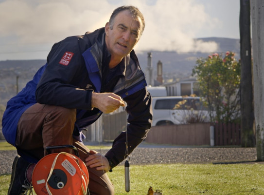
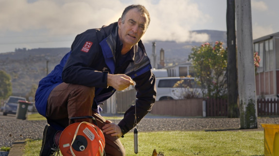
Well we're out here at Moanarua, monitoring pisometers.
Groundwater flows into the pipes and fills them up.
So what I'm going to do here is to measure the level of the ground water with an
electronic tape measure, and when I lower it down
it will eventually beep when I hit the water. There we are 2.6.
So this is another of our piezometers in the network, we've got 23 of them across the city
and this one's on the low lying part. And if i drop this tape measure into the bore here,
i don't have to go far at all. In fact i've hit the water there, just 50 centimeters down
less than half a meter we have saturated ground. So in each of these holes we have an electronic
pressure transducer, this is one here hanging in the hole and they measure the
water level and how it goes up and down over time by taking a recording every 15 minutes,
and we measure how much it changes when it rains or when the tides are moving. At this site here
we have about a one centimeter shift. When the sea over there a kilometer away
moves up and down a meter here we move about one centimeter. And we measure all
the changes during the seasons all through the year using these pressure transducers
which give us an idea of how much the groundwater is moving from site to site across the city.
In New Zealand we have a problem with the shallower the groundwater the higher the
potential for liquefaction during earthquakes, and we saw that in Christchurch that the very shallow
areas where the groundwater was very shallow were you know experienced very very bad liquefaction.
As groundwater rises it can then start to flood into basements and subsurface
structures and it can get in and start to to rust concrete reinforcing and saturate things.
There's also the fact the rising groundwater exacerbates these other problems,
so as it comes up it means there's less room there to store water that would infiltrate from
the surface so it exacerbates the flood in estuaries or flooding and in rivers.
And then this other wider issues that generally if you're living on land that's very saturated your
houses will be damper, so you get condensation and mildew and problems inside which have
corresponding health problems with respiratory illnesses and things. As groundwater rises
the ground's often a lot softer and behaves differently and can behave quite differently
once when it's saturated in terms of its geotechnical properties so you have to design
accordingly. Particularly you know if you want to build a hospital or some school or one of these
structures where you need a a better foundation design. In Dunedin we have suburbs scale
kilometers by kilometer where there's some places that are worse than others
and some places which are more exposed to the potential effects of sea level rise than others.
And if we go to Christchurch we have quite a different setting we have there the rain is not as
important certainly during the summer if it rains the pavements are often hot and it evaporates and
not so much water goes into the ground. We get groundwater flow coming down from the Canterbury
plains and the springs come out forming the haven and they they drive where the groundwater is high.
So these suburb scale things are really important when we get down to trying to look at the risk.
And our real worry for the future of south Dunedin is this relationship between the groundwater
coming up and the surface water coming down and having less room to store that water in the
ground. It's dependent partly on the geology, but it's also dependent on how much the groundwater
responds to the push from the sea level. And that's what we've been trying to find out when
we're doing all of this work with the boreholes. So what we're trying to understand is the natural
changes to the groundwater system. The groundwater goes up and down depending on the geology
and the forces of rain coming on top and the sea pushing in the side,
and there's that natural fluctuation. And on top of it we've constructed a city
and so we modulate the natural system with the urban environment, having roofs and drains and
hard street services has an effect.
So what we're trying to do with this project is to use south Dunedin to understand that relationship
between the natural system and the urban system. And how much it's been modulated. And what does
that mean for the amount that we're going to have to do that in the future. What sort of engineering
solutions do we need in order to be able to maintain this land and use it in the future.
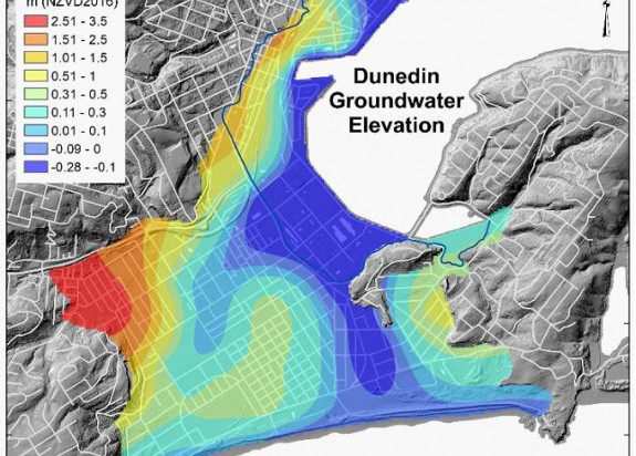
The monitoring also indicates that some of the flat low-lying land beneath parts of the city is much less permeable than initially expected.
“Gentle pumping of wells is able to disturb the chemistry of groundwater long after water-levels have recovered, and many places have ‘topsy turvey’ temperatures that are warmest in June and coldest in December,” Dr Cox says.
This suggests water is not moving rapidly through the ground, and that is good news. Further monitoring and analysis needs to continue to improve our understanding of the relationship between present day tides and groundwater levels and the effects of future sea level rise.
South Dunedin Future, a collaborative project between Otago Regional Council and Dunedin City Council are pleased to see these results from the groundwater data being collected.
ORC General Manager Operations, Dr Gavin Palmer says, “Technical staff from both councils will use the analyses presented in this report to help inform the next phase of scientific work, while consulting with the community on potential options to mitigate against natural hazards and climate change impacts through the South Dunedin Future project. Ongoing monitoring and further analyses of the likely effects of climate change on groundwater are still needed to confirm these initial observations based on one year of monitoring only.”
DCC Infrastructure Services General Manager Simon Drew says, “The DCC has budgeted $35 million to spend on flood reduction in the South Dunedin area over the next decade. This new report will form an important part of the technical basis for developing options for exactly how that money will be spent. Monitoring observations are available for free download here.
“We look forward to further collaboration with the Otago Regional Council, GNS Science, the community and others as we work towards safely adapting to the effects of climate change.”
Dunedin groundwater is monitored by Otago Regional Council and GNS Science, with chemical analyses completed by University of Otago. The city is seen as a test case for developing methods to monitor, map, model and help mitigate the effects of rising groundwater and sea-level rise. This research forms part of the NZSeaRise Endeavour Programme(external link) funded by MBIE(external link).
The baseline data presented in the report are accessible through contacting ORC, who maintain the Dunedin groundwater database along with rainfall and river levels.