RiskScape accurately models rainfall induced landslide impact of Cyclone Gabrielle
During Cyclone Gabrielle, the RiskScape software tool was applied to a real-life situation, allowing decision-makers to prioritise their cyclone preparedness, response, and recovery activities in real-time.
RiskScape assesses risk to people, buildings, and infrastructure from natural hazards such as volcanic eruptions, earthquakes, landslides, tsunamis, and floods. The tool is one of very few open-source risk models available worldwide, allowing many sectors, such as land-use planners, asset managers, emergency managers, and insurance providers, to better manage the significant risks from natural hazard events.
Cyclone Gabrielle in February 2023 caused loss of life and significant damage to buildings, infrastructure, and primary production, particularly in Hawkes Bay and Tairāwhiti. Responding agencies urgently needed to assess and understand the impacts of the landslides and flooding to make informed response decisions. A new multi-hazard risk model and information-sharing platform was needed, and fast.
As Cyclone Gabrielle approached, as a trial, MBIE and Toka Tū Ake EQC funded the development of a customized risk modeling dashboard to support the response efforts.
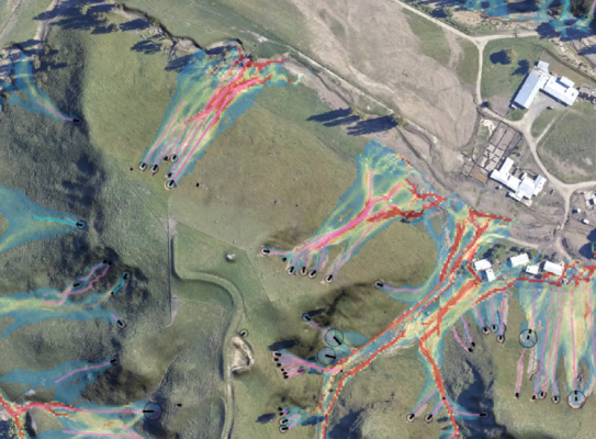
Using data from the rainfall-induced landslide model, the team first created a landslide impact model as the cyclone was approaching, which enabled forecasts to be calculated estimating impact to properties, state highways, and the rail network.
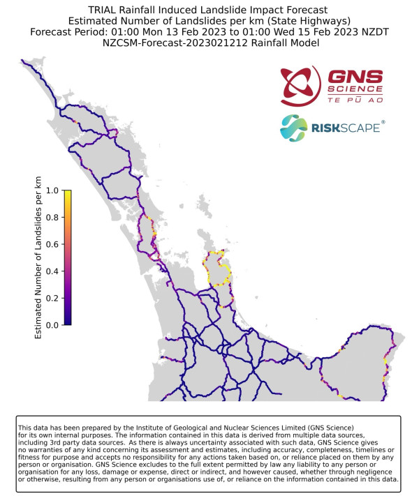
RiskScape proved accurate, with initial residential claims similar to impact forecast spatial distribution and numbers.
Following this, the team created a rainfall-induced landslide impact forecast and issued these twice daily to response agencies during the extreme weather event.
RiskScape proved accurate, with initial residential claims similar to impact forecast spatial distribution and numbers. This allowed recovery agencies and researchers to easily understand the complex data and stress test different impacts. The tool also fosters collaboration among agencies by offering a centralised platform for analysis.
The success from this trial provides a base to build on for future events, providing fast and accurate insights for decision-makers. The positive outcomes from this trial underscore RiskScape’s ability to ensure communities are equipped to handle future events.
RiskScape is ready to provide evidence-based advice and modelling to help New Zealand avoid, mitigate or adapt to these hazards.
Where to next?
There are many hazards that we’re yet to face associated with redevelopment, urban growth, climate change, and land-use planning. RiskScape is ready to provide evidence-based advice and modeling to help New Zealand avoid, mitigate, or adapt to these hazards. Success will be RiskScape being used to inform regional planning and ultimately save lives and maintain our vital infrastructure.
If you'd like to read more case studies on RiskScape head to the RiskScape Community Case Study Page(external link)
More about RiskScape
Developed by GNS Science, NIWA and Toka Tū Ake EQC with software team, Catalyst IT, the tool helps scientists build customised workflows, replacing in a matter of minutes a process that would usually take days of coding.
The tool uses information about our hazards, our people, and our built environment to model the impacts on communities from natural hazard events.
Having a robust model is largely thanks to years of long-term investment in scientific research through the New Zealand Ministry of Business, Innovation and Employment (MBIE) Hazard and Risk Management Programme (Strategic Science and Investment Fund).
Understanding the impact of natural hazards on our people and property allows communities to better anticipate, respond to, and recover from those events, and provides an evidence-based future-proofing lens for local planning purposes.
RiskScape is highly customisable and can process multiple hazards and the effect they have on societal assets. For example, how might earthquake shaking affect a timber-framed house on a concrete foundation, compared with a brick house on timber piles.
To make these calculations RiskScape uses a variety of geospatial algorithms to spatially link a hazard layer representing the ground shaking intensity combined with an exposure layer representing the building footprint and construction information.
These are combined with a vulnerability model that defines how the building will perform when subjected to different ground shaking intensities to gain an estimation of the expected damage.
RiskScape Platform vs. RiskScape Engine
RiskScape is available two ways, via the online Platform and the Engine. With the RiskScape Engine – think standalone, where users construct their own model using their data in a RiskScape pipeline of code. For the RiskScape Platform – think hosted full service, where users get the RiskScape teams expertise to build custom end-to-end risk analysis solutions including models and dashboards to visualise outputs in a cloud-based online environment.
Talk to the team
Interested in learning about how RiskScape could help your business or organisation? Contact Helen Barnes, Senior Business Development Manager on h.barnes@gns.cri.nz or +64 21 348 948.