RiskScape’s rich data powers critical loss modelling tool, PRUE
Understanding the impact of natural hazards on people and property is critical for the Natural Hazards Commission (NHC) Toka Tū Ake. Knowing what to expect from future natural hazard events allows them to plan and prepare for New Zealand’s physical and economic security.
This enhanced knowledge is possible thanks to RiskScape, which now proudly powers the Commission’s loss modelling tool, ‘PRUE’. Co-developed by GNS Science and NIWA, in partnership with NHC Toka Tū Ake, RiskScape provides a modern software platform for risk modelling, underpinned by the latest scientific research.
Using a custom-built web interface, NHC Toka Tū Ake can produce a custom view of loss assessment from a natural hazard event in minutes. PRUE provides its stakeholders with robust estimations of losses after an earthquake event. It can model residential housing damage costs for any given future earthquake and give a view of that risk to reinsurers.
Working with a collaborative platform like RiskScape allows local authorities and reinsurers to operate from the same data, ensuring a shared understanding and common operating platform, and supporting aligned decision making.
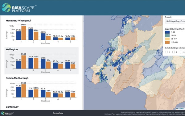
The scale and value of this was demonstrated during Exercise Rū Whenua 2024, a national response exercise simulating a magnitude eight rupture of the Alpine Fault. The NHC Toka Tū Ake team was able to quickly calculate residential loss and costs and provide that advice to decision makers to inform response and recovery efforts.
RiskScape easily integrates new research as it is developed which makes it, and the GNS team, a key partner for NHC Toka Tū Ake in the ongoing delivery of their loss modelling development roadmap. GNS is excited to support PRUE as it progressively expands to model losses relating to other hazards, like volcanic activity, liquefaction, and tsunamis, as well as complex multi-hazard events, like earthquake-induced landslides.
GNS Science and NHC Toka Tū Ake are currently working to develop an understanding of losses posed by the Auckland Volcanic Field. Once complete, data from projects like this will be woven into RiskScape to provide an increasingly enhanced view of the impact we might expect from hazard events across the motu.
RiskScape’s robust modelling is largely thanks to years of long-term investment in scientific research through the New Zealand Ministry of Business, Innovation and Employment (MBIE) Hazard and Risk Management Programme (Strategic Science and Investment Fund).
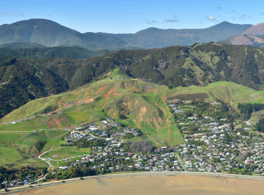
Main image: Widespread land sliding in farmland just outside of Atawhai, Nelson – September 2022.