View Bio
Scientists zero in on submarine volcanoes
New Zealand and American scientists will use one of the world’s most sophisticated unmanned submarine vehicles during the next three weeks to investigate two seafloor volcanoes in the Kermadec Arc, northeast of Bay of Plenty.
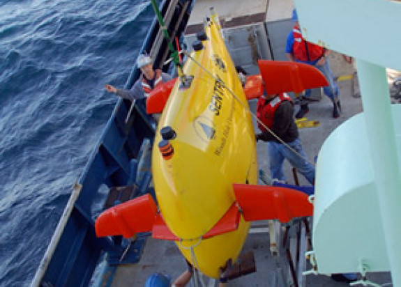
The project is a collaboration involving GNS Science, the Royal New Zealand Navy(external link), and US-based Woods Hole Oceanographic(external link) Institution, which owns and operates the autonomous underwater vehicle Sentry(external link).
The multi-purpose 18-day voyage, scheduled to leave Auckland on March 3, is built around a regular Navy supply trip to Raoul Island on HMNZS Wellington. This particular voyage will support GNS Science, the Department of Conservation, and the Meteorological Service.
Sentry - the autonomous underwater vehicle - will be deployed from the Royal New Zealand Navy patrol vessel for its day-long missions to skim over the seafloor and gather data.
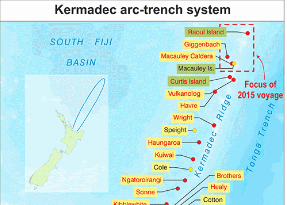
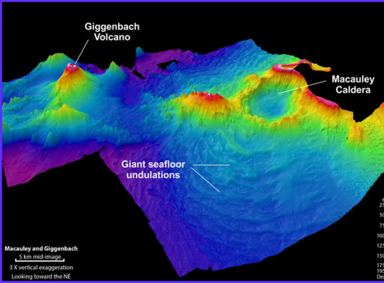
The target seafloor volcanoes – Macauley Caldera and Giggenbach - are actively venting hot water and gases on the seafloor and are within 100km of Raoul Island. Both volcanoes have been investigated by surface ships on previous voyages, but this will be the first time they have been explored extensively at close range.
Sentry will travel over the volcanic structures at walking speed and at a pre-determined height above the seafloor. It will build detailed three-dimensional maps and measure up to 12 different chemical and physical parameters of the ocean and seabed.
It will return to the ship after each mission to download terabytes of data, have its batteries recharged, and to be programmed for its next deployment. It is scheduled to make eight dives during the voyage, covering about 10 square kilometres of seafloor per dive.

Project leader Cornel de Ronde said the voyage was part of a long-term GNS Science programme to build detailed maps and collect geological data, including hydrothermal venting, at about 30 major submarine volcanoes in the Kermadec Arc, which runs between Bay of Plenty and Tonga.
This will be Sentry’s second visit to New Zealand. During a GNS Science-led voyage in 2011, it gathered detailed information on four submarine volcanoes northeast of White Island.
Sentry is the ideal vehicle for obtaining comprehensive information and understanding on the seafloor and the environment around these submarine volcanoes,” said Dr de Ronde, a marine geologist at GNS Science.
“It provides the appropriate level of detail on the geology of the seafloor, the hydrothermal systems, deep-sea habitats, and the occurrence of mineral deposits.”
The project is part of a multi-year research programme by GNS Science to map and understand tracts of seafloor in New Zealand’s vast offshore territory. New Zealand has sovereign rights over an area of seafloor totalling 5.7 million square kilometres.
This is equivalent to 14 times the size of California or 1 percent of the Earth’s surface. This area is largely unmapped and unexplored. The New Zealand landmass equates to just 4 percent of this submerged area – sometimes referred to as the continent of Zealandia.
GNS Science, with support from its international colleagues, has been systematically investigating the volcanic features of the Kermadec Arc since the late 1990s.