Waiwera geothermal system 'rapidly recovering'
Utilising thermal infrared surveying and UAV technology, GNS scientists have identified a recovering geothermal system in Waiwera, Auckland.
Use of TIR technology
A recently published paper (external link) by Graham Paul D. Viskovic (GNS Science), Nick Macdonald (GNS Science) and Michael Kühn (GFZ Helmholtz Centre for Geosciences) describes how thermal infrared surveying and UAV technology can be used to survey geothermal springs.
Thermal Infrared (TIR) technology is commonly used by research teams at GNS Science who use it to map and monitor geothermal surface features. The team have developed techniques to use TIR data to assess field wide heat flow, providing insight into the “health” of geothermal reservoir at depth. This technology is also used to map potential hazards within geothermal areas.
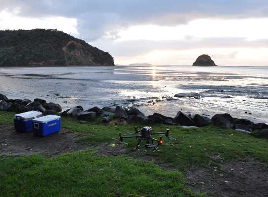
Field work and Unmanned Aerial Vehicle (UAV) surveying in the Waiwera area was undertaken in February and May of 2022. Nick Macdonald, Geothermal Field Technician, operated a DJI UAV to collect aerial thermal infrared and visual photography of the area. A total of 245 photographs were taken at a flight height of 120m altitude (above ground level). By identifying contrasting temperatures in the thermal imagery, the source of the hot water flows could be determined.
Collecting images at the right time of day proved to be the main challenge of the surveying. Elevated day-time temperatures would obscure any effective details in the thermal infrared imagery. This was due to the sand and rocks on the beach being heated up to a similar temperature of the warm water seeps, making any contrasts not visible on the images. High tides in the morning and evening restricted collection of TIR images to cooler times of the day.
Recovery position
During a visit on 23 May 2022, a survey taken in the early morning at low tide was able to achieve an acceptable thermal contrast between the warm beach seeps and the background geology that indicated flowing hot water from fractures in the foreshore that were independent of storm water drains, confirming that several bores are actively overflowing. Although heat of the beach springs is not at the level observed historically in either temperature or flow rate, the hydrothermal system did appear to be recovering slightly. This is similar to observations of spring recovery in Rotorua, suggesting that although the water pressure within the reservoir recovers, recovery of heat is more complicated.
Water levels in the Auckland Council monitoring bore suggests that recovery has currently stabilised. If remaining overflowing bores were plugged and no other bores began leaking due to pressure, it is possible the beach springs could increase from the current level. If water-take was to return to previous levels, the pressure of the subsurface may reduce again, resulting in lower natural flow to the surface, and reduction in spring activity again. Improved management and allocations could minimise the risk of this occurring.
Waiwera's history
In the 1960s, overallocation of the Waiwera hydrothermal system caused its natural beach springs to cease. The Waiwera Thermal Resort (aka Waiwera pools), the main user of geothermal water in the area, closed and stopped pumping in 2018. After the closure of the resort, reports began to filter in that the geothermal system had begun to rapidly recover, causing problems with existing user bores, abandoned bores began reactivating and reports of possible reactivation of the beach springs.
Having 80% of the total consented Waiwera Precinct allocation, the closure of the Waiwera Thermal Resort presented a unique case study of how fast a geothermal system could bounce back after curtailment by its main user. Reports of hot water reported on the beach needed to be identified and it was believed that a thermal infrared survey of the beach may be able to differentiate between storm water discharges and any nearby springs.