
CarbonWatch-Urban: Reducing Aotearoa’s urban carbon emissions
Carbon dioxide from urban fossil fuel burning is responsible for 40% of Aotearoa’s gross carbon emissions. Understanding how much carbon dioxide is released by our cities and how much is absorbed by urban green spaces is key for effective mitigation policies.
GNS Science Te Pū Ao is leading research to map urban carbon dioxide sources and sinks for every town and city in Aotearoa, providing vital information to support the transition to a low-carbon economy and help Aotearoa meet our net-zero 2050 target.
Overview
Urban development and the form of our cities can influence both emissions and absorption of carbon dioxide (CO2), but there is insufficient data to assess how urban vegetation and land management choices impact our net emissions.
Initial data shows that the land carbon exchange – the release of carbon through respiration and removal of carbon through photosynthesis – can offset a significant fraction of emissions in Aotearoa’s cities. We will determine how much carbon is taken up by our urban environments, and how development styles and management of urban parklands can enhance or reduce this carbon uptake.
The programme will develop high-resolution emissions information, mapped across space, time, and sector, for every urban centre, verified by atmospheric measurements. New techniques using atmospheric trace gas measurements will be developed to enhance ‘bottom-up’ inventories of urban greenhouse gas emissions and sinks.
These ‘flux’ maps will be examined to determine how urban development choices, land cover and societal and economic drivers influence emissions.
This highly detailed information on Aotearoa’s urban greenhouse gas emissions will allow central and local government, iwi, urban and traffic planners, and industry to better monitor their current emission sources, enable targeted mitigation strategies, and to change policy to support low-emissions outcomes.
Research aims
- Determine how CO2 fluxes (the overall rate of emission and removal of CO2) differ with varying stages of urban development, tracking CO2 fluxes across suburbs that are being newly developed, recently developed and established, using atmospheric measurements.
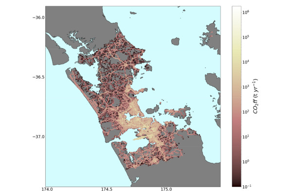
- Map Auckland’s fossil fuel derived CO2 emissions and biogenic CO2 fluxes at high spatial and temporal resolution, using a robust combination of flux modelling, inversion modelling and atmospheric observations.
- Map urban fossil fuel and biogenic CO2 fluxes for all of Aotearoa’s towns and cities, validated by atmospheric observations using a mobile laboratory.
- Determine how societal and economic drivers impact emissions and sinks across urban environments, and evaluate the impact of urban development.
Detailed suburb-scale case studies
We will directly measure CO2 fluxes for individual suburbs and urban parklands in Canterbury and Auckland, determining how greenfield developments and urban parkland redevelopment impact net carbon fluxes.
These case studies will provide the first direct evidence in Aotearoa of how development choices impact urban fossil fuel CO2 and biogenic CO2 fluxes.
World-leading investigation of CO2 sources in Auckland
The programme will extend the existing measurements and instrumentation at four sites in Auckland, established for CarbonWatch-NZ. Existing instrumentation measured CO2, carbon monoxide (CO) and methane (CH₄) in real time, and measures radiocarbon in CO2 (¹⁴CO2) from weekly flask samples. We will add innovative real time measurements of carbonyl sulphide (COS) and black carbon aerosol (BC).
Together these measurements will allow us to separate Auckland’s CO2 into its sources –photosynthesis and respiration from urban vegetation, wood burning, traffic, and the burning of other fossil fuels.
We will expand the Mahuika and UrbanVPRM model products, that map Auckland’s fossil fuel and biogenic CO2 in both space and time. By extending these back over 10 years, we can investigate how changes in urban development have impacted emissions.
We will use a technique called "atmospheric inversion" to evaluate and improve the emission models using the atmospheric measurements.
Urban CO2 emissions information for every town and city in New Zealand
We will extend the emission maps of urban CO2 emissions to all of Aotearoa’s towns and cities, improved with the knowledge gained from the detailed studies in Auckland.
Our custom-designed mobile electric vehicle lab will be equipped to take a range of atmospheric gas measurements - CO2, CO, CH₄, ¹⁴CO2, COS, BC and Radon. We will survey approximately 15 urban areas, spanning varying climates, geographies and population sizes. The measurements will be used to further validate and improve the emission maps across Aotearoa.
Understanding the societal and economic impacts on urban emissions and sinks
We will draw upon existing social and economic datasets e.g. wellbeing, deprivation indexes, and combine these with our spatial emissions information to better understand how socio-economic factors impact our urban emissions.
Working with iwi and government stakeholders, we will use our flux models and datasets to understand how real-world examples of past development have impacted the carbon cycle.
The 10-year dataset will allow us to analyse how urban development and development styles has influenced urban emissions. Socio-econometric modelling will be used to forecast future urban emissions under different scenarios.
Publicly available emissions and sink information for all of Aotearoa’s towns and cities
To ensure the data is made available in a form that can be readily integrated into existing and new policy frameworks, we’re working with researchers from StatsNZ, Ministry for the Environment and Ngāti Whātua Ōrākei, and our Stakeholder Advisory Group to co-design the outputs. We will create customisable dashboards, visualisations, datasets and outreach tools, accessible online.
Funding and collaborators
This research programme is funded $10,548,102 from the Ministry of Business, Innovation and Employment (MBIE) Endeavour Fund.
The project is led by GNS Science Te Pū Ao, with research partners NIWA, Manaaki Whenua Landcare Research, University of Auckland, DotLovesData, Ministry for the Environment, StatsNZ and Ngāti Whātua Ōrākei. We are also working with international collaborators from Australia, USA and Switzerland, and a stakeholder advisory group from central government, local government, iwi and industry.
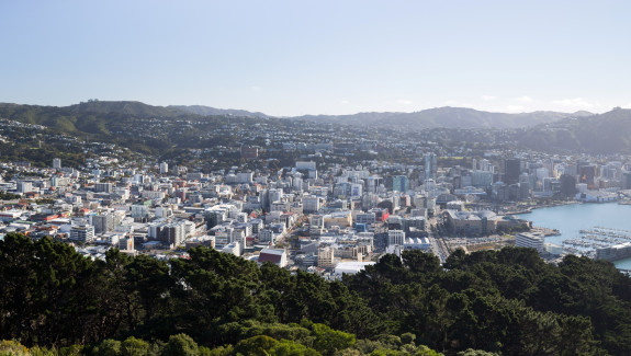
Wellington panorama(external link) photo credit: asgw, CC-BY-2.0