Crustal structure of Zealandia

GNS Science scientists are using geological and geophysical techniques to explore the nature of the crust beneath our feet in New Zealand and beneath the waves of the largely submerged continent of Zealandia.
Overview
The shape of Aotearoa New Zealand is controlled by what lies beneath us – the plate boundary forces and changes in the properties of the continental crust. Our crustal exploration focuses on both New Zealand’s onshore and offshore areas.
Crustal structure has a first-order influence over which parts of Zealandia are above sea level and which parts are below. It also has a major influence on the distribution of crustal earthquake activity in New Zealand.
The project aims to understand
- how the crustal structure varies across Zealandia
- the tectonic drivers for this variation
- and the influence this variation has on the occurrence of natural hazards
To achieve these objectives, we
- explore the shape of the crust of Zealandia using observations from seismic, gravity and magnetic field data as well as the Integrated Ocean Discovery Program (IODP)
- explore the deep properties of the crust, recording earthquakes and other soundwaves on seismometers to determine physical properties of the crust and associated links to earthquake activity
The project
The shape of the continent of Zealandia
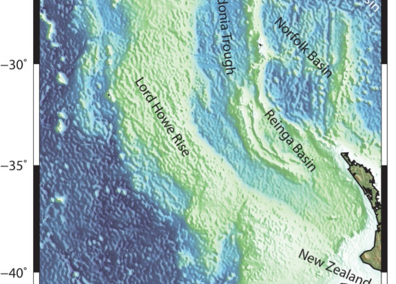
New Zealand sits in the middle of the continent of Zealandia. Zealandia was formed on the margin of the supercontinent Gondwana. It broke away, moving north and thinning in the process. Today, around 94% of Zealandia lies underwater – that’s around 4.9 million sq km.
Scientific exploration of the continent has revealed it has a large range of crustal thicknesses. From ~10 km thick in the offshore New Caledonia Trough to >40km thick under the higher elevation parts of South Island. Most of the onshore areas are thicker than 25km and most of the offshore areas are thinner than 25km. The region has elevated bathymetry which means it sits higher than the surrounding oceanic crust. Just like an iceberg, the thicker crustal regions sit higher out of the water and the regions with thinner crust are below sea level.
Exploring crust with gravity and seismic methods and IODP drilling
Crustal structure is explored using several geophysical techniques. Seismic exploration can be used to image the structure and physical properties of the crust. The thickness of and internal layering structure within in the crust can be imaged with these techniques. Seismic wave speeds (sound waves) normally increase with depth within the crust and these can be used to identify regions where crustal structure differs. Variations in crustal structure in Zealandia are caused predominantly by either crustal formation history (volcanism, sedimentation or metamorphic processes) or by deformation from plate tectonic forces.
Other exploration tools useful for exploring crustal structure include potential field methods. These include making measurements of the variations in the Earth’s gravity or magnetic fields. The gravity field is affected by variations in the density of rocks and the magnetic field variations can highlight changes in the concentration of magnetic minerals in rocks.
Using these tools, scientists aim to understand the thickness and shape of the different blocks of crust that make up Zealandia.
- In the onshore areas, these blocks are often deformed by tectonic motion between the two tectonic plates.
- The offshore areas, far away from the plate boundaries, are useful for studying New Zealand’s makeup as these areas are composed of some of the same rock types observed onshore in New Zealand, but they are less deformed.
Understanding the offshore areas helps build a framework for understanding New Zealand onshore crustal structure. This is important as the boundaries between regions of different crustal blocks can be nucleation zones for earthquakes.
In recent years, the IODP drilling ship the JOIDES resolution has made several cruises in New Zealand waters. Data from these voyages has revealed new tectonic histories for our offshore areas, including information on how the crust of the Zealandia continent has subsided through time since it first formed on the edge of Gondwana.
Deep structure of the crust
One way to image what is going on deep in the crust beneath the surface in New Zealand and to understand crustal structure is to map out the depth at which frictional rock deformation gives way to slow ductile creep.
This depth is called the brittle-ductile transition and most earthquakes occur above this depth. It’s largely linked to how hot the earth is in a region, as heat flow controls the behaviour of the crust. When it gets warm enough at depth, the brittle faulting of earthquake activity gives way to more the more ductile, slowly flowing behaviour of hotter rocks.
- This depth is called the base of the seismogenic zone and is where the deepest crustal earthquakes occur.
- The brittle-ductile transition is shallowest in hot areas like beneath the volcanic zone in North Island. But maybe deeper in colder areas of New Zealand that are less deformed by the motion between the tectonic plates.
Imaging the depth distribution of earthquakes in New Zealand reveals the nature of the deep crust and its influence on risk of earthquake activity.
Earthquakes can also be used to image the crust by measuring the time it takes for earthquake energy to travel from the source to a group of seismometers on the surface. The speed of different types of earthquake waves can vary and from this variety we can identify differences in crustal rock compositions and structure. Maps showing the shape and thickness of our continental crust, its differing formation history and the variation of these around New Zealand, can be made by studying the seismic signals from earthquakes.
GNS Science maps of Zealandia
GNS Science maps available for purchase from our online shop:

