2021 National Tsunami Hazard Model
Database
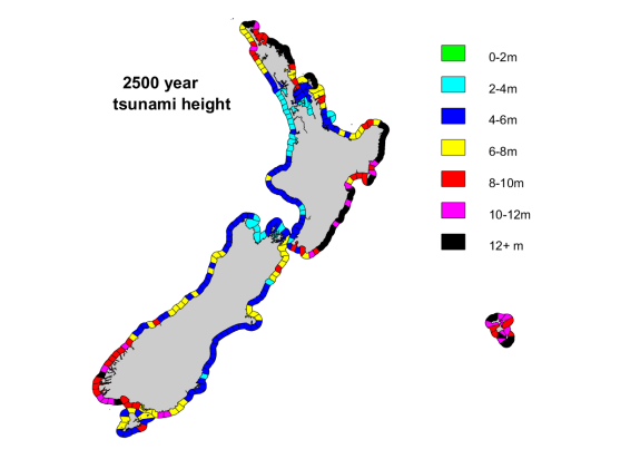
This is the 2021 version of the National Tsunami Hazard Model, which covers the entire coast of New Zealand. It provides estimates of the maximum tsunami height at the coast to be expected within specified time periods and confidence levels.
Overview
This dataset defines the maximum tsunami height (maximum amplitude) expected to be exceeded once every 100, 500, 1000 and 2500 years on average at the 50th and 84th percentile of confidence, as estimated by the model described in Power et al. (2022). The dataset also defines the coastal sections that were used for this modelling. The expected maximum tsunami heights are presented for each of these coastal sections.
Please note that the expected maximum tsunami height will typically only occur at one location within each coastal section. It is a conservative (pessimistic) assumption if this height is used throughout the section.
This model has been used as a basis for defining tsunami evacuation zones for several regions of the country, and for estimates of the tsunami risk posed to people and buildings.

-
Downloads
Download the dataset (ZIP, 603 KB)
This contains key results from the 2021 National Tsunami Hazard Model in the form of GIS ShapefilesReview of Tsunami Hazard in New Zealand, 2021 (PDF, 4.5 MB)
This report explains the methodology used by the hazard model.2021 NTHM All-Coast Tsunami Hazard Data
(PDF, 48 MB)Detailed results for individual 20km sections of coast, including hazard curves and deaggregation plots, can be found in this reportMore information from the original 2013 report can be found here.
Please read the Terms of use below.
-
Terms of use
This project was supported by the New Zealand Ministry of Business, Innovation and Employment (MBIE) through the Hazards and Risk Management programme (Strategic Science Investment Fund, contract C05X1702).
The Institute of Geological and Nuclear Sciences Limited (GNS Science) and its funders give no warranties of any kind concerning the accuracy, completeness, timeliness or fitness for purpose of this dataset. GNS Science accepts no responsibility for any actions taken based on, or reliance placed on the dataset and GNS Science and its funders exclude to the full extent permitted by law liability for any loss, damage or expense, direct or indirect, and however caused, whether through negligence or otherwise, resulting from any person’s or organisation’s use of, or reliance on, the dataset
This dataset is intended to be used in conjunction with Power et al (2022), and with acknowledgement of the limitations of the methodology expressed there (and in particular those on page 53 of that report).
These data are licensed under a CC BY 4.0 licence (which requires users to give appropriate credit to the Institute of Geological and Nuclear Sciences Limited t/a GNS Science).
Cite as: Dataset: GNS Science. (2021). National Tsunami Hazard Model - 2021. GNS Science. https://doi.org/10.21420/C3CK-FB93
Cite as: Report: Power WL, Burbidge DR, Gusman AR. 2022. The 2021 update to New Zealand’s National Tsunami Hazard Model. Lower Hutt (NZ): GNS Science. 63 p. (GNS Science report; 2022/06). https://doi.org/10.21420/X2XQ-HT52