New Zealand Paleoseismic Site Database v1.0
Database
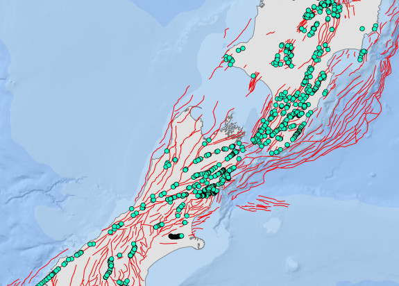
This database contains paleoseismic data collected at specific sites along active faults throughout New Zealand.
Overview
The paleoseismic data are grouped into three sets - Slip Rate, Earthquake Timings, and Single-Event Displacement. Each set has a range of attributes including an Easting and Northing for each site. This dataset is version 1.0 and is a Microsoft excel spreadsheet containing sites along faults in the New Zealand Community Fault Model v1.0.

-
Downloads
Download the dataset (XLSX, 780 KB)
Version 1.0 is described in the Design and Overview report (PDF, 5.9 MB)
The attributes are described in the Data Dictionary (PDF, 1.2 MB)
Cite as: Litchfield NJ, Humphrey J, Morgenstern R, Langridge RM, Coffey G, Van Dissen RJ. 2022. New Zealand Paleoseismic Site Database: design and overview of version 1.0. Lower Hutt (NZ): GNS Science. 27 p. (GNS Science report; 2021/52).
Find more content related to:
GNS Science topics
Locations
- Whakatū / Nelson
- Rangitāhua / Kermadec Islands
- Rēkohu / Chatham Islands
- Rakiura / Stewart Island
- Murihiku / Southland
- Ōtepoti / Dunedin
- Ōtākou / Otago
- Ōtautahi / Christchurch
- Waitaha / Canterbury
- Kaikōura
- Te Tai Poutini / West Coast
- Te Tauihu-o-te-waka/ Marlborough
- Aotearoa / New Zealand
- Te Tai-o-Aorere / Tasman
- Te Whanga-nui-a-Tara / Wellington
- Manawatū-Whanganui
- Central Plateau
- Taranaki
- Te Matau-a-Māui / Hawke's Bay
- Te Tai Rāwhiti / Gisborne
- Te Moana-a-Toi / Bay of Plenty
- Waikato
- Tāmaki Makaurau / Auckland
- Te Tai Tokerau / Northland