Many changes made since Ruapehu's 95-96 eruptions
Ten years ago New Zealand got world media attention when Mt Ruapehu started a series of spectacular eruptions through its Crater Lake. Remarkably, there were no deaths or serious injuries given that the eruptions coincided with the ski season.
An early sign that trouble might be brewing was the Crater Lake heating to 50 degrees Celsius in January 1995. This is about 10C higher than its usual peak temperature.
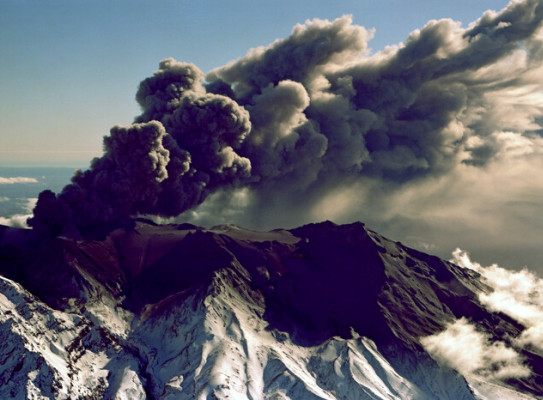
An eruption in June 1995 which destroyed scientific monitoring equipment at the Crater Lake marked the start of the biggest eruptions on the mountain since 1945. Sporadic volcanic activity continued, but Ruapehu didn't get public and media attention until a dramatic eruption on 23 September 1995.
It produced an eruption plume 12km high, threw rocks 1.5km from the crater, and generated lahars down three river valleys. Even bigger eruptions followed in October 1995 and in June and July of 1996, with ash falling up to 300km from the mountain.
The eruptions over a 13-month period ejected a total of 60 million cubic metres of volcanic ash and were a timely reminder of the volcanic threat in New Zealand . The ash discoloured rivers and water supplies, ruined crops, and killed about 2000 sheep that ate ash-laden pasture. Ash even closed North Island airports and state highways on several occasions.
Ash in snow-melt entered the Tonagriro River and caused $22 million worth of damage to hydro-electric turbines at the Rangipo Power Station. It was closed for many months for repairs.
Despite the lasting images of Ruapehu's temper tantrums, there is virtually no trace of the eruptions on the mountain today. The main outcomes have been improved emergency management procedures, a better understanding by businesses of their vulnerability to eruptions, and better scientific monitoring of New Zealand 's volcanoes.
The 1995-1996 eruptions kick-started a range of improvements. We are much better equipped to deal with such an eruption if it occurred again.
"We now have eruption detection systems for the Whakapapa ski field, revised volcanic alert levels, and a volcanic ash advisory service for the aviation industry. Scientific monitoring equipment has improved vastly. There are now 14 seismic instruments and nine GPS instruments covering the greater Tongariro National Park area."
The upgraded instrument network replaces a smaller group of ageing instruments that dated back to the early 1950s. The new equipment, installed over the past two summers under the Earthquake Commission-funded GeoNet project, has improved the ability of scientists to detect volcanic unrest at the Tongariro volcanoes.
"It enables us to give better information to responding agencies in the event of an eruption. The new network is also providing high quality data needed to advance the knowledge of volcanism."
Information from the instruments is telemetered to GeoNet data centres at Wairakei and Lower Hutt so scientists can assess earthquakes and ground deformation as they occur on or near Ruapehu, Tongariro, and Ngauruhoe.
"This enables us to quickly recognise heightened seismic activity that may precede an eruption. One of the factors we watch for is changes in volcanic tremor. This can be an indication that magma is moving inside the volcano."
The continuously telemetered GPS instruments detect any surface deformation that may be caused by movement of magma under Mount Ruapehu , or movement on the geological faults surrounding the volcano. Together with regular checks of the Crater Lake temperature, the chemistry of the lake water, and volumes of gases being emitted, a much improved monitoring regime is now in place.
To mark the tenth anniversary of the eruptions, about 70 scientists, emergency managers and other stakeholders are holding a three-day workshop at Whakapapa starting on October 14. The aim is to share lessons learnt from the eruptions and be better prepared for future eruptions. Activities for the public, including guided walks and field trips, are scheduled for the Saturday and Sunday.