Antarctica geological maps
GNS Science and its predecessor, the New Zealand Geological Survey, have been an integral part of New Zealand’s Antarctic research programme since the International Geophysical Year (1957-58).
Antarctica for all its ice and snow cover has more than 52,000 km2 of rock and unconsolidated cover deposits that record a rich geological, geomorphological and glaciological history of the continent. Our work has resulted in significant gains in understanding the glacial geology and this information is contributing to research into Antarctic glacial dynamics in response to changing climatic conditions.
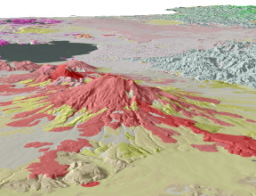
Geology of southern Victoria Land Antarctica (MQM22)
Covering the largest ice-free area of Antarctica, the Geology of southern Victoria Land published in 2012 replaced the 1st edition 1:250,000 map generated by New Zealand geologists Bernie Gunn and Guyon Warren in 1962. Southern Victoria Land is crossed by a major rift basin, its uplifted shoulder forming the Transantarctic Mountains escarpment. Associated with this rift are large stratovolcanoes on Ross Island and on the mainland nearby. In the Transantarctic Mountains, Neoproterozoic and Paleozoic granitoids and their host rocks are overlain by a thick sequence of Devonian-Triassic sedimentary rocks and these are intruded by Jurassic dolerite sills. Eocene to Holocene deposits in the Dry Valleys and beneath the Ross Sea, including the products of Miocene and later volcanism, preserve a record of ice sheet and glacier fluctuations.
The work integrated and summarised all previous geological studies in the Dry Valleys and Ross Island area. A comprehensive search and review of existing geological maps, databases, research papers and geological theses was completed and information compiled at 1:50 000 on 46 sheets. Some new fieldwork was also undertaken. Elsewhere satellite and aerial photograph interpretation helped provide the first systematic overview of glacial deposits in the region. Data have been captured and stored in an ArcGIS® database, from which a web map service is delivered, and high-quality map printed. The full-colour 1:250,000-scale map accompanies a 135-page companion book that includes stunning colour photographs of the Antarctic landscapes, a large number of illustrations, and numerous diagrams summarising aspects of the geology.
-
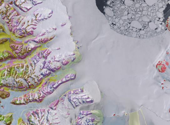
Highlights: Geological map of Southern Victoria Land
Highlights of the southern Victoria Land geological map include the differentiation of the Proterozoic high-grade Skelton Group metamorphic basement from four suites of Late Proterozoic to early Paleozoic Granite Harbour Intrusives granitic plutons. Extensive intrusion by the Ordovician Vanda Dike Swarms is also depicted. The Beacon Supergroup stratigraphic succession is depicted in terms of the Devonian Taylor Group and the Permian to Triassic Victoria Group, differentiated into 14 constituent formations. The Jurassic igneous Ferrar Supergroup sills and dikes that intrude across and close to the Kukri Erosion Surface are shown.
The map shows for the first time the context of the Cenozoic volcanism (McMurdo Volcanics) of Mt Erebus/Ross Island and southern Ross Sea region with that of the Transantarctic Mountains. Rock units are mapped primarily in terms of their rock type (lithology) but also differentiated on age of deposition, eruption and intrusion, either using colour variation or appropriate overprints. Structural features of the intervening Ross Sea Basin are shown together with the recent stratigraphic drilling sites.
The map also provides the first systematic overview of glacial deposits in the region, which range from older Miocene-Pliocene sequences inland, to younger Quaternary tills pertaining to the last glacial maximum near the coast. Tills have been grouped on geomorphological criteria using dating, elevation and composition information wherever possible, distinguished from colluvium, scree, lake and delta deposits, dunes, beach deposits, fan gravel and alluvium.
The work integrated and summarised all previous geological studies in the Dry Valleys and Ross Island area. A comprehensive search and review of existing geological maps, databases, research papers and geological theses was completed and information compiled at 1:50 000 on 46 sheets. Limited new fieldwork was carried out in some areas in late 2008.
SCAR GeoMAP
Following the successful completion of the 1:250 000 Geological Map of New Zealand and the release of the Geology of southern Victoria land, GNS Science launched an ambitious project to build a similar high-quality dataset over the entire Antarctic continent. This initiative was supported by the Scientific Committee on Antarctic Research in 2014 through the SCAR GeoMAP Action Group.
With collaboration from enthusiastic researchers from 14 nations supported by a hard-core of 11 students who helped capture data from hard copy maps, a GIS dataset describing exposed bedrock and surficial geology of Antarctica was created. The latest version (v.2022-08) contains 99,080 polygons unified for use at 1:250,000 scale, but locally there are some areas with higher spatial resolution. Geological unit definition is based on a mixed chronostratigraphic- and lithostratigraphic-based classification.
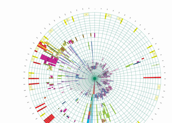
GeoMAP is the most detailed geological map dataset covering all of Antarctica and includes an innovative time-space plot legend. Description of rock and moraine polygons employs international GeoSciML data protocols to provide attribute-rich and queryable information, including bibliographic links to 589 source maps and scientific literature. It depicts ‘known geology’ of rock exposures rather than ‘interpreted’ sub-ice features and is suitable for continent-wide perspectives and cross-discipline interrogation. Version 2022-08 is available for download free under a CC-BY licence, or can be viewed via an interactive web map.